
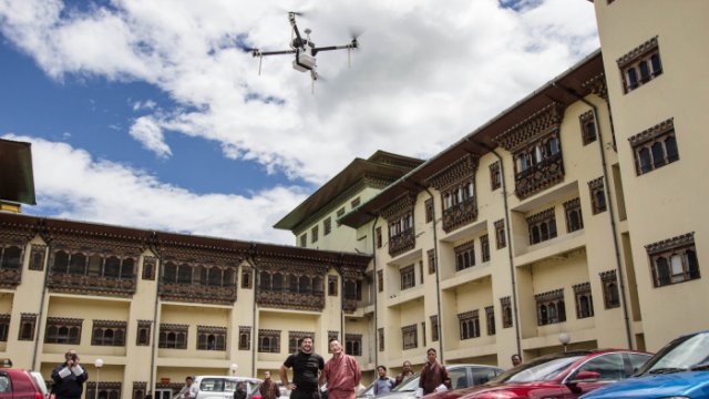
 It’s one of the world’s first drone-based delivery networks, but it’s not in the Silicon Valley. It’s in Shangri-la. A Silicon Valley startup is piloting a low-cost drone-based delivery project in the remote Himalayan nation of Bhutan that could save lives in far-flung rural communities—and perhaps pioneer the system globally.
Category Archives: VTOL
New Kamov Rotary UAV
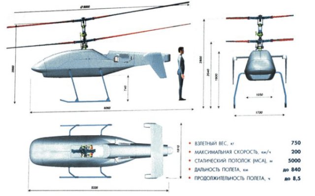 Kamov has revealed details of its new Ka-175 vertical takeoff and landing reconnaissance and strike unmanned aerial vehicle (UAV), which could make its maiden flight within a year. Continue reading
DJI’s New Heavy-Load UAS has Retractable Landing Gear
DJI is continuing to expand its horizons into the pro market with the new Spreading Wings S900. Continue reading
Hummingbirds Hover Better than Black Hornet
When it comes to flight, nature just has the edge on engineers. This is according to a study comparing hummingbirds with one of the world’s most advanced micro-helicopters. Researchers found that – in terms of the power they require to lift their weight – the best hummingbird was over 20% more efficient than the helicopter.
Kansas City Man to use UAS for Search and Rescue
A Kansas City man plans to explore the lifesaving potential of drones. Lance Nash of Hex FX Aerials has been using unmanned aircraft to shoot video of events for the last two years. Continue reading
Unmanned K-Max to Undergo Further Testing
Lockheed Martin is preparing a series of demonstration flights to prove the capability of its K-Max unmanned air vehicle to transport and deploy an autonomous ground vehicle. In an effort to prove the potential of “robots moving robots”, the VTOL UAV – derived from the manned Kaman helicopter – will next month take part in the US Army-led trials which will see it carry a Lockheed Martin Squad Mission Support System (SMSS) at Fort Benning, Georgia. Continue reading
DJI DropSafe Emergency Parachute System
DJI DropSafe is an parachute system for DJI multirotors s that launches a parachute in the event of a power failure. DJI calls it a “drop speed reduction system,” and does not guarantee that it will protect equipment or prevent injury. Continue reading
ING Robotic Aviation and ASG Mapping use Robotic Aircraft for Advanced Agricultural Data Gathering
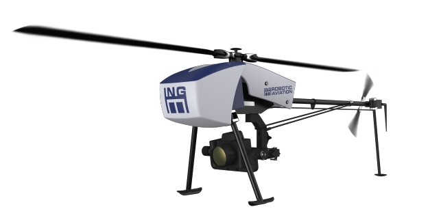 ING Robotic Aviation is partnering with ASG Mapping to rigorously assess and develop the application of small robotic aircraft systems for gathering high quality, positionally accurate, and interoperable geospatial data.