
In Switzerland emergency centres respond to about 1,000 to calls about hikers lost or injured in the forests annually, according to the University of Zurich. But research the university has completed, in collaboration with Università della Svizzera italiana and the University of Applied Sciences and Arts of Southern Switzerland, may help speed up the search and rescue process.
The team recently developed a software that enables drones to autonomously detect and follow forest paths—giving them the ability to find lost hikers faster than humans can on their own.
“While drones flying at high altitudes are already being used commercially, drones cannot yet fly autonomously in complex environments, such as dense forests,” University of Zurich Prof. Davide Scaramuzza said, according to a news release. “In these environments, any little error may result in a crash, and robots need a powerful brain in order to make sense of the complex world around them.”
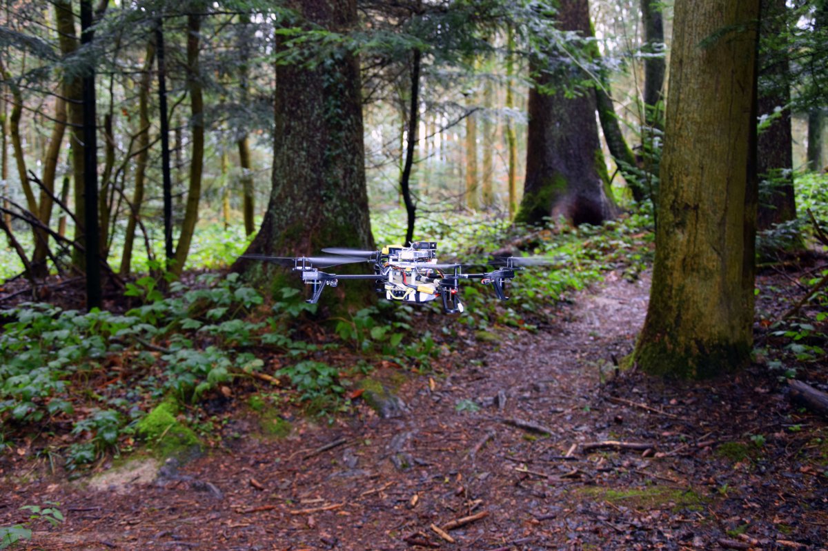
Researchers essentially created a custom, vision-based drone for the research, PhD student Matthias Fässler said. They started with a Parrot AE frame, and to get it to fly in a complex environment like a forest, they developed software to run behind all the control parts stabilizing the UAS for autonomous navigation.
“We worked on drones that are stabilized using vision and the other lab worked on machine learning to teach the drones how to detect forest trails in camera images,” Fässler said. “The drones learned what the forestry looked like so they could fly fully autonomously and follow the trails.”
How it works
The UAS the researchers developed observes the environment through a pair of small cameras. Rather than relying on sophisticated sensors, it uses artificial-intelligence algorithms to interpret the images to recognize man-made trails. If a trail is visible, the software steers the drone in the corresponding direction.
This is quite a challenging problem for a drone—one even humans struggle with—but researchers were able to overcome it using a Deep Neural Network, which is a computer algorithm that learns to solve complex tasks from a set of “training examples,” much like a brain learns from experience, according to the university.
“One of the big challenges was getting the drone flying just using cameras and inertial sensors, and making that work reliably and robustly,” Fässler said. “On top of that a big challenge was collecting a good data set of forest trails to make the drone learn and be able to reliably classify or detect trails in an image.”
To gather enough data for their algorithms, the team hiked along different trails in the Swiss Alps for several hours. During these hikes, cameras attached to their helmets took more than 20,000 trail images. When tested on a new trail, the deep neural network found the correct direction in 85% of cases. Humans guessed correctly 82% of the time.
The future
This type of UAS application is still in the research stage, but Fässler said he hopes emergency teams will be able to use drones during search and rescue missions someday in the future. They team has received positive feedback from organizations who see the value in this type of research and technology. They know that while drones will never replace human rescuers, they can certainly help them get to victims faster.
“What they like about drones is they’re fairly easy to use and they can go to places rescuers can’t,” he said. “If you need to rescue a victim you’ll always need a person there as well, but you can speed up the search if you have drones looking. This is what they can do very well.”
Source: Inside Unmanned Systems