
 It sounds like an awesome wintertime trip: Snowmobile to the middle of nowhere, set up camp and fly radio-controlled airplanes for a couple of weeks. Now take that same scenario and move it to Antarctica in the austral summer. Throw in a 10-hour snowmobile ride across the hard, wind-carved snow surface.
“It’s a bit of exploratory science, I think,” said John Cassano , associate professor in the Department of Atmospheric and Oceanic Sciences and a fellow at the Cooperative Institute for Research in the Environmental Sciences at the University of Colorado in Boulder .
He is also a co-principal investigator on the Antarctic Automatic Weather Station (AWS) programme, led by the University of Wisconsin-Madison . In 2009, Cassano and his team made history with the longest series of unmanned aerial vehicle (UAV) flights in Antarctica. It’s a short history so far: The British were the first to successfully fly a UAV in 2007.
The 2009 campaign, which was followed by another series of flights in 2012, took place over a region known as Terra Nova Bay , where a polynya of open water exists within the surrounding sea ice. The phenomenon is particularly interesting to atmospheric scientist like Cassano due to the strong exchange of heat and moisture between the ocean and air – a process normally muffled by the presence of sea ice.
The Aerosonde MK4.4 UAV, manufactured by an Australian company, made 16 flights covering about 11,000 kilometers over more than 130 flight hours in 2009 alone. It required a team of pilots and engineers to operate and maintain. It had a wingspan of more than three meters, using a pickup truck to launch it into the air.
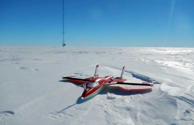
The Small Unmanned Meteorological Observer (SUMO) aircraft – those radio-controlled airplanes – sport a wingspan of 80 centimeters and weigh less than half a kilogram. It can fly as fast as 35 meters per second with a battery life of 30 minutes. It requires a couple of people to operate. Most common fixes can be accomplished with glue and a little patience.
“It’s really easier to operate. We’re on the very simple end of the UAV spectrum,” Cassano said during an interview at McMurdo Station after returning from a two-week expedition at site on the Ross Ice Shelf known as the Alexander Tall Tower . The Tall Tower is a 30-meter-high weather station installed about three years ago to go above and beyond the normal AWS, which is about three meters tall.
Both the large and small UAVs employed by Cassano in Antarctica target the atmospheric boundary layer, the lowest part of the troposphere that is important for understanding processes involving energy exchanges between the planet’s surface and the atmosphere. The boundary layer in Antarctica can be up to 1,000 meters deep.
The coupling between the atmosphere and the surface is a critical process that ultimately controls all of the weather and climate we experience, according to Cassano. The data collected by the SUMO airplanes will help researchers evaluate the validity of weather forecasts coming from the Antarctic Mesoscale Prediction System (AMPS) .
“That’s a really strong test of the model’s representation of physical processes that control the boundary layer,” Cassano said. “It will help us improve the models.”
The 2009 flights over Terra Nova Bay, about 300 kilometers north of McMurdo Station, recorded prodigious exchanges of energy at the surface, as cold air from the continent swept across the much warmer ocean waters. That was expected.
What surprised Cassano was that the boundary layer over the Ross Ice Shelf was still being controlled by surface processes even though there was a relatively small exchange of energy or heat compared to Terra Nova Bay. He had similar results during a handful of test flights of the SUMOs in 2012 on the McMurdo Ice Shelf.
“I was surprised when I saw that data,” he said, referring to the 2012 pilot project. “We wanted to explore that a bit more.”
That exploration took Cassano, postdoc Melissa Nigro, also from CU-Boulder, a graduate student from New Zealand and a mountaineer across more than 160 kilometers by snowmobile in one long day (and back again about two weeks later). The team completed about 40 flights with the SUMO aircraft, which carry sensors to record temperature, pressure, humidity and wind continuously.
Scientists have found through the weather data collected by the Tall Tower – just out of vertical reach for the other 65 stations in the AWS network – that there are strong inversions of up to 10 degrees Celsius starting only five meters above the snow surface.
Typically, the air near the surface of the Earth is warmer than the air above it. Under certain conditions, the normal temperature gradient becomes inverted. Cassano said his team is currently putting together climatology on the strength and frequency of those inversions. The data from the SUMOs will fill in additional gaps to the picture both vertically and horizontally.
“You can’t just look at the surface and assume you know what’s going on,” Cassano said. “We can fill in the gaps of what Antarctica looks like in the three-dimensional sense.”
The small UAVs, costing only about $5,000 each versus $75,000 for the Aersonde, allowed the team to take some additional risks, sending the small aircraft into freezing fog and dense clouds.
Cassano said the team will return with the UAVs for the 2015-16 field season, though the target of that campaign is still being discussed.
“[The SUMO] really lends itself to these deep-field deployments. You can take them anywhere around the continent and fly them,” Cassano said. “I’m enjoying the ease of logistics.”
Photo: One of the Small Unmanned Meteorological Observer (SUMO) aircraft sits on the ice near the Tall Tower on the Ross Ice Shelf – John Cassano
Source: Antarctic Sun