SimActive Inc., a developer of photogrammetry software, has announced that the Republic of Korea Agency for Defense Development (ADD) has selected Correlator3D. Their use of the software will include processing UAV and satellite imagery. The transaction was facilitated through a SimActive partner in the region, GeoFocus Inc. Continue reading
Category Archives: Software
Kittyhawk Announces Automated Flights for Enterprise Drone Operations Platform
Kittyhawk, a supplier of commercial drone operations software, has announced new features to its best-in-class platform. Kittyhawk is adding an automated flight system to their Flight Deck feature set to work in conjunction with its recently released secure live streaming feature.
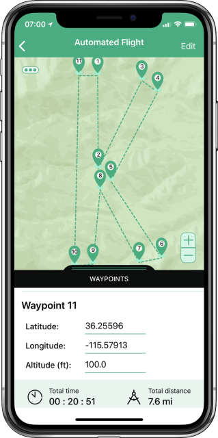
The new automation features allow operators to plan missions in the Kittyhawk mobile application and then execute the entire flight from takeoff to landing with unlimited waypoints. Like all Kittyhawk features, great care has been taken to create a safe and useful user experience. The app has incorporated safety features to ensure that operators are not able to initiate an automated flight to a place beyond the range of the radio and drone; like trying to launch a mission in California when you’re currently in New York. The Kittyhawk software uses the geolocation of the operator to show only flights that are possible to complete — avoiding potentially expensive and dangerous mistakes. Continue reading
Consortiq Upgrades CQNet Drone Software
Consortiq has rolled out several improvements to its award-winning CQNet drone management software over the festive period. Continue reading
US Deploys AI Algorithms on ScanEagle
Earlier this month at an undisclosed location in the Middle East, computers using special algorithms helped intelligence analysts identify objects in a video feed from a small ScanEagle drone over the battlefield. Continue reading
Kittyhawk Launches Intelligent Flight Profiles
Kittyhawk has announced Flight Profiles, a key new feature to its expanding enterprise platform. After collaborating with customers, it became clear that as more organizations teams leave the “freelancer” or “contractor” model and begin to train more employees to fly, that a set of “common-sense” presets was necessary to help further reduce risk and empower their workforce. Continue reading
Kespry Integrates AirMap Airspace Intelligence
AirMap has announced a new partnership that brings AirMap airspace intelligence to the Kespry platform for commercial drone operations. Continue reading
AirMap Now Offers Automated Airspace Authorization
Through a partnership with the Federal Aviation Administration (FAA), AirMap Inc. is now a UAS service supplier for the Low Altitude Authorization and Notification Capability (L.A.A.N.C.). Continue reading
Dedrone Launches DroneTracker 3
Dedrone has announced a next generation software upgrade, DroneTracker 3. DroneTracker is the industry’s first airspace security solution that includes automated summary reporting for instant diagnosis of drone airspace activity. Continue reading


