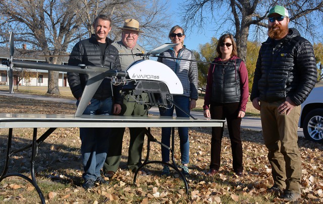
Last week, man and machine joined forces in an attempt to control an unprecedented – yet recurring – natural disaster that routinely strikes rural Goshen County. In 2015 and 2016, Fort Laramie National Historic Site experienced the effects of a 100-year flood – an event that has a 1-percent chance of occurring during any given year. Continue reading
Category Archives: Geology
MasterFly Long Endurance Mapping Drone
Trigger Composites designs and manufactures unmanned aerial systems (UAS) for a wide range of industries, including the mining sector. Founded in 2006 in Poland, the company aims to provide high-quality products that meet client requirements cost-effectively. Continue reading
Rwanda Forges Forward in Drone Mapping Use

After Rwanda made waves in the news early last year for allegedly being the first country to approve drone delivery, people payed attention. The country, with its rolling hills and one of the fastest growing economies in Central Africa has already established regulations regarding drones and become a vanguard of sorts for the region. Continue reading
Hyperspectral Imaging Reveals Coral Health

A hyperspectral camera was used in the project to collect data in 270 colour bands, which is far more than the human eye can see – Queensland University of Technology
A high-definition camera and drone have captured an aerial view of Western Australia’s Ningaloo Reef in an effort to monitor the health of the pristine region. Queensland University of Technology researchers scanned 40 hectares of Ningaloo Reef, the largest existing fringing reef in the world, over 30 minutes, 100 metres above the sea surface. Continue reading
IARPA Announces Winners of the Multi-View 3D Mapping Challenge
The Intelligence Advanced Research Projects Activity, within the Office of the Director of National Intelligence, announced that they have selected the winners of the Multi-View Stereo 3D Mapping Challenge. Continue reading
Fly-Off Compares Aerial Survey Drones
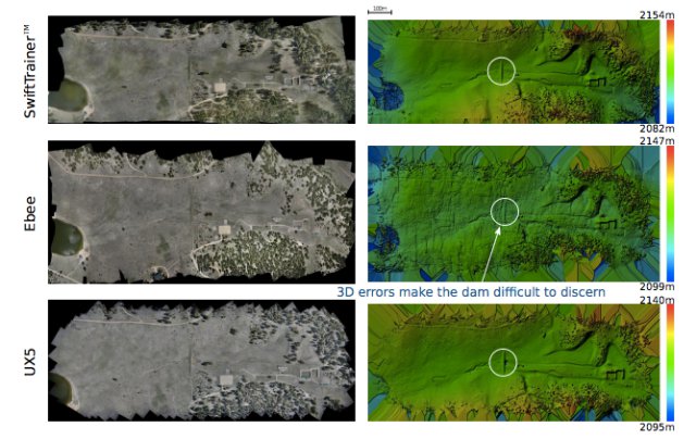
As the number of choices for drone based photogrammetry continue to grow it becomes increasingly difficult to determine which platform to select. A recent CH2M Hill sponsored fly-off between the BlackSwift SwiftTrainer, SenseFly eBee and the Trimble UX5 HP and provided a unique opportunity to compare between available platforms, and the resulting analysis reveals significant differences between leading systems.
Heliceo Offers World First in Geomatics

The DroneBox technology is scalable, patented, and designed to equip both plane and multi-rotor unmanned aerial systems, as well as terrestrial photogrammetric and bathymetric unmanned vehicle systems (UVS). Continue reading
Terra Drone and Hitachi Team on UAV Land-Surveying
Terra Drone, an Asian service provider of unmanned aerial vehicles, and Hitachi Construction Machinery, the world’s leading manufacturer of construction and mining equipment, have announced a partnership to accelerate full-automatic UAV operation at construction sites.
