
A hyperspectral camera was used in the project to collect data in 270 colour bands, which is far more than the human eye can see – Queensland University of Technology
A high-definition camera and drone have captured an aerial view of Western Australia’s Ningaloo Reef in an effort to monitor the health of the pristine region. Queensland University of Technology researchers scanned 40 hectares of Ningaloo Reef, the largest existing fringing reef in the world, over 30 minutes, 100 metres above the sea surface.
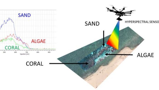
Lead researcher Associate Professor Felipe Gonzalez said the data would help build a fingerprint of the reef, showing coral, sand, algae and other species.
The images will be processed to reveal their minute detail and will provide a valuable tool to assess the health of the region.
“If the coral is healthy or unhealthy it will show the difference,” he said.
A normal camera can collect data in three colour bands: red, green and blue.
This camera collects data in 270 bands which is far more than the human eye can see.
The technology, on a bigger scale, is being used by NASA in Queensland to capture the Great Barrier Reef from the sky.
In that research a bigger camera is mounted on a GulfStream IV jet.

QUT research engineer Dr Dmitry Bratanov said their camera worked better in bad weather.
“Clouds can be a show-stopper for satellite data collection but this UAV camera can fly closer and get the job done,” he said.
Checking the health of an area so vast and isolated as the marine park was not cheap or easy but the drone technology is changing that.
“We can cover much more area than a ground-based survey can cover in the same time, and we can achieve unprecedented, centimetre-level resolution compared to what a manned aircraft or satellite can achieve,” he said.
Fringing reefs grow near the coastline and around islands, separated from the shore by narrow, shallow lagoons.
The technology used to capture Ningaloo Reef is also being used on land to help monitor issues like invasive weeds.
Source: ABC
“You can cover much more area in one single flight to what a manned aircraft, a satellite or underwater surveys could do”
Must be off context somehow as the precise opposite is true. 15minutes at low altitude cant ever cover what 7 hours at high altitude can do. Plus you see the clouds better from the air than from the ground. The benefit of drone is the cost efficiency in small sized jobs, not the wide area work.