
A group of Chinese scientists is harnessing the power of specialized drones in an effort to enhance the monitoring of carbon emissions linked to human activities.
These unmanned aerial vehicles (UAVs) have demonstrated promising potential, with the capacity to provide more accurate data regarding emission changes compared to existing carbon monitoring satellites. Global carbon dioxide emissions from energy-related sources have recently reached a record high of 36.8 billion tonnes, as reported by the International Energy Agency (IEA).
While satellites have been employed by various countries, such as NASA’s Orbiting Carbon Observatory, to monitor emissions, tracking from space is not without its challenges. Factors such as cloud cover, aerosols, land topography, and wind speed can impact the accuracy of satellite measurements. Yang Dongxu, a researcher at the Chinese Academy of Sciences’ Institute of Atmospheric Physics, highlighted this issue, stating that “existing and even near-future satellite measurements cannot meet the frequent monitoring requirements for anthropogenic emissions” in the study published in the peer-reviewed journal Advances in Atmospheric Sciences.
The Mission
Driven by the desire to fine-tune carbon detection, Yang and his team embarked on a mission to develop a more precise system for measuring localized emissions attributed to human activities. Their efforts resulted in the creation of the Low-cost UAV Coordinated Carbon Observation Network (LUCCN), detailed in their paper published in the peer-reviewed journal Advances in Atmospheric Sciences.
While the use of drones for greenhouse gas monitoring is not new, LUCCN presents an innovative approach by combining ground monitoring stations with an “intelligent multi-aircraft flight system” utilizing UAVs. The ground-based stations are equipped with solar panels and feature sensors within weatherproof enclosures, complete with mounted weather stations to record external environmental changes.
In contrast to fixed-wing aerial drones, quadcopter drones are used due to their ability to hover in place and maneuver more precisely. The LUCCN system is designed to make autonomous flight decisions based on information gathered during the initial exploratory flight mission.
The research team emphasized the importance of developing improved monitoring systems for anthropogenic carbon emissions, as the insufficient understanding of such emissions in power generation, cities, and industry has led to significant uncertainties in global carbon budgets.
LUCCN Prototype
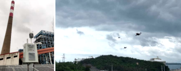
The first prototype of LUCCN, which comprised five ground stations and four drones, underwent testing over a three-day period in May at a power plant in Shenzhen, located in China’s Guangdong province. During the test, the ground stations detected a single signal, while the drones successfully made measurements from the emissions plume released by the plant. This was attributed to the drones’ ability to access the relatively high altitudes of the emission sources.
However, the emissions data collected by LUCCN slightly exceeded data from an open-source dataset, prompting the research team to work on network improvements to eliminate the disparity. Yang stated, “The UAV sampling strategy and emission estimation methods require further exploration.”
The LUCCN method enhances the monitoring process by combining multiple aircraft with ground stations, providing a more comprehensive and accurate picture of carbon emissions. The paper noted that “satellite remote sensing combined with near-ground measurement is required in the future,” with LUCCN’s “detailed measurements of local carbon emissions and even ecosystem carbon cycle processes” set to bolster China’s emissions monitoring efforts.
The LUCCN test was integrated into China’s Global Carbon Dioxide Monitoring Scientific Experimental Satellite (TanSat) ground system in May and will complement space-based monitoring. Launched in 2016, TanSat is China’s first carbon dioxide monitoring satellite and has been previously utilized by Yang’s research team to track human-caused carbon emissions, further advancing our understanding of carbon emissions and their impact on the environment.
The full 7-page paper is available here.
Top Photos: the campaign in Shenzhen. The left-hand panel shows the ground-based station near the power plant, with an NDI sensor in the enclosure. The right-hand panel shows a swarm of drones for coordinated observation
Source: Interesting Engineering