
Forests and orchards are not only vital for the nature as the lungs of the earth but also crucial as a source of food production. In these fields, so-called Oracha-forest could mainly benefit from UAV-based remote sensing due to relative difficulties in assessing and controlling their environment.
Although various research has been performed in different fields using UAVs and remote sensing, they were non-exhaustively documented for Oracha-forest. Moreover, the challenges and potential solutions were less noticed than deserved. The current work, therefore, focuses on providing a comprehensive review of UAV-based remote sensing, applications, and response to the concerns in both orchards and forests.
Furthermore, three indices were innovated for fair quantitative analysis of the research in this field. The performed research was continentally analyzed according to the indices. Research diversity and concentration, UAV platforms, and the used sensors related to other relevant data were evaluated. To conclude, the data, the challenges, and UAV-based remote sensing pros and cons in Oracha-forest were discussed. Finally, several future works, measures, and suggestions were also derived.
Introduction
Remote sensing benefits different platforms for data acquisition without touching the object, area, and phenomenon under investigation. These platforms are spaceborne, airborne, and wheeled vehicles. Satellite systems are proper for earth observation analysis at large-scale levels, but their spatial resolutions are limited. Although the high-resolution satellite systems have been available (Lan et al., 2010), the environmental conditions for instance cloud coverage and fixed timing acquisition affect the capability of satellite images (Eskandari et al., 2020). Also, satellite images are expensive and usually their resolution and quality are not satisfactory and applicable (Jang et al., 2020). This makes it difficult to use satellite images for monitoring orchars forest trees, especially for small environments and in limited time.
In recent years, using airborne remote sensing systems is remarkably rising in environmental monitoring. Aerial remote sensing vehicles in comparison with satellite-imaging systems present a flexible and custom platform to collect high spatial resolution imagery inappropriate atmospheric and solar conditions (Lan et al., 2010; Bagheri, 2016).
Unmanned aerial vehicles (UAVs) as aerial remote sensing platforms overcome the limitations of large-area satellite imagery (Padua et al., 2018) for Orcha-forest monitoring. Nowadays, the availability of many types of UAVs from rotary-wing to fixed-wing has increased (Zhang et al., 2021). Pre-defined flight mission, remote controlling the motion and direction from a ground station (Fraga et al., 2014), capturing ultra-high-spatial-resolution imagery, low-cost data acquisition, and low maintenance, are some of the advantages of the UAV platforms (Radoglou-Grammatikis et al., 2020).
On the other hand, their coverage ranges and their flight endurances are restricted (Caruso et al., 2019). The stability, safety, reliability, and autonomy of UAVs, combined with the specificity of the sensors, are the factors that allow the successful implementation of this new platform for a certain range of applications of remote sensing (Saari et al., 2009). Therefore, during the last decade, numerous research have been carried out in the field of using UAVs for Orcha-forest trees monitoring and a literature review shows that the use of this technology is increasing in this field.
So, the current comprehensive review aims to analyze the research findings in a specific area named Orcha-forest including the types of cameras and platforms used and types of studied trees and measured variables. This paper point out the lack of the current knowledge, research need and future research orientation in the field of Orcha-forest trees. according to the opportunities and current challenges of this technology. Additionally, three indices have been innovated to discover the research orientation and to unbiased quantitative review.
Materials and Method
In this study, 111 scientific research and review papers in the field of using UAVs for monitoring and management of orchard and forest trees during 2000–2022 were downloaded from scientific databases including Web of Science, Scopus, Directory of Open Access Journals (DOAJ), and Google Scholar. The search keywords were UAV, orchard, forest, aerial remote sensing, precision agriculture, and aerial monitoring and UAV sensors.
Orchard Trees Monitoring and Management by the UAV
The contribution of research carried out on the different trees is as follows: 17% of research on orange, 2% on lemon, 2% on grapefruit, 2% on mandarin, 19% on olive, 11% on apple, 8% on peach, 6% on mango, 6% pear, 5% on almond, 5% on banana, 3% on avocado, 3% on oil-palm, 2% on apricot, 2% on kiwifruit, 2% on chestnut, 2% on coffee, 2% on nectarine, 2% on coconut. Twenty horticultural products were studied, of which 22% were citrus fruits.
Conclusion
This paper provides a comprehensive review of UAV-based remote sensing, applications, and response to the concerns in both orchard and forest trees. Research diversity and concentration, UAV platforms and cameras related to other relevant data were descriptively analyzed. Above all, three remarkable indices were innovated for fair quantitative analysis of the performed research in this field, including ARI, NJI and KBI.
The full paper is available here.
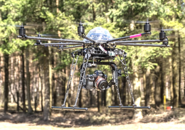
Photo: Octocopter mounted with a fixed lens Sony A7r RGB camera – MDPI
Source: Science Direct