
Glacier-related applications of unmanned aircraft systems (UAS) in high mountain regions with steep topography are relatively rare. This study makes a contribution to the lack of UAS applications in studying alpine glaciers in the European Alps.
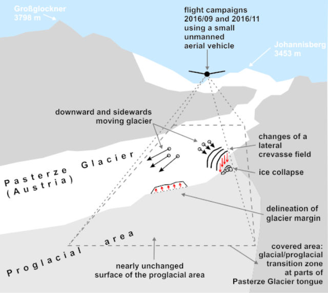
We transferred an established workflow of UAS-based change detection procedures to Austria’s largest glacier, the Pasterze Glacier. We focused on a selected part of the glacier tongue and its proglacial vicinity to obtain detailed knowledge of (i) the behaviour of a lateral crevasse field, (ii) the evolution of glacier surface structures and velocity fields, (iii) glacier ablation behaviour and the current glacier margin, and (iv) proglacial dead ice conditions and dead ice ablation.
Based on two UAS flight campaigns, accomplished in 2016 (51 days apart), we produced digital elevation models (DEMs) and ortho-photos with a ground sampling distance (GSD) of 0.15 m using Structure-from-Motion (SfM) photogrammetry. Electrical resistivity tomography (ERT) profiling was additionally conducted in the proglacial area.
Results indicate distinct changes in the crevasse field with massive ice collapses, rapid glacier recession, surface lowering (mean of −0.9 m), and ice disintegration at the margins, calculated degree day factors on the order of −7 to −11 mm d−1·°C−1 for clean ice parts, and minimal changes of the debris-covered dead ice in the proglacial area.
With this contribution we highlight the benefit of UAS in comparison to commonly used terrestrial methods and satellite-related approaches.
Source: MDPI