
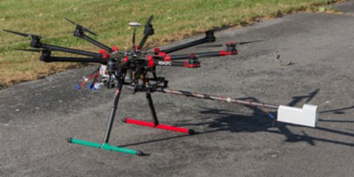
 The NOAA Air Resources Laboratory’s Atmospheric Turbulence and Diffusion Division (ATDD) has received Federal Aviation Administration (FAA) certification to fly its DJI S-1000 small Unmanned Aircraft Systems (sUAS) at the Knox County Radio Control Society’s model flying field near Knoxville, TN.
This is the first time NOAA has received FAA certification to fly a UAS with a weather observing payload inside the continental U.S. Flights at the model flying field, to be conducted in mid-June, will be used to test the airborne instrument package and conduct data comparisons with instruments on the ground in preparation for ATDD’s field campaign in mid-July near Belle Mina, Alabama.
The July field campaign will collect boundary layer measurements to better understand thunderstorm genesis mechanisms (convective initiation) in the Southeastern United States. The campaign is part of the NOAA Convective Initiation Study funded by the Disaster Relief Appropriations Act of 2013. FAA approval to fly for the July field campaign is expected near the end of June. The sUAS will also be used in the NOAA VORTEX-Southeast field campaign in Alabama next year to help understand the formation, intensity, structure and path characteristics of tornadoes.
Background: The ATDD has been working with the NOAA Unmanned Aircraft Systems (UAS) Program and the Office of Marine and Aviation Operations’ Aircraft Operations Center to develop the capability to fly the sUAS for boundary layer research. Because the sUAS is considered an aircraft, FAA certification is required prior to flight in each geographic area. ATDD acquired the sUAS DJI S-1000 octocopter back in October, 2014. The octocopter is capable of lifting approximately ten pounds of payload to an altitude of up to 1000 feet above ground level. The payload includes a small downward looking infrared camera, a visible camera, and a radiosonde package to measure air temperature and relative humidity.
Significance: This emerging technology will provide NOAA with a new observing platform that will provide critical missing data between land-based measurements and satellite remote sensing measurements. By using the sUAS, observations can be obtained both vertically and horizontally to get an accurate picture of the scale and extent of the temperature and moisture fields. The diurnal development of the vertical temperature and humidity profiles in the atmospheric boundary layer are linked to the aggregated sensible and latent heat fluxes at the land surface and help provide a better understanding of convective initiation. With the ability to profile temperature and relative humidity in the lower boundary layer and map the thermal land surface temperature fields at the same time, the sUAS provides an inexpensive platform capable of capturing the dynamics of a developing boundary layer and linking that development to observed changes to the heat and water fluxes at the land surface.
Source: Air Resources Laboratory