
Doug Stow, a geography professor from San Diego State University, is developing a programme that uses before-and-after aerial imagery to reveal infrastructure damage in a matter of minutes.
“After a disaster, emergency responders need to know what’s damaged and what’s functioning,” said Stow, who recently received $365,000 from the National Science Foundation to support this research.
The work builds on ongoing research by Stow and Pete Coulter of the university’s Center for Earth Systems Analysis Research for the U.S. Department of Homeland Security and the Navy Postgraduate School.
Bird’s-eye patrol
The idea behind the project is this: Emergency officials identify ahead of time the critical infrastructure they will need in case of an emergency—power stations, bridges, dams, hospitals, and others—and researchers like Stow send out unmanned aerial vehicles(UAVs) and piloted light sport aircraft (LSA) to take bird’s-eye pictures of the intact buildings and environment.
During the flight, the UAVs record their GPS locations and altitude and report back with both their positions and the images, which are filed into a computer program.
If a disaster occurs, emergency managers can immediately send back a UAV or LSA to take an aerial image from the exact same location and altitude, process the before-and-after images to detect changes, and report back with a damage map.
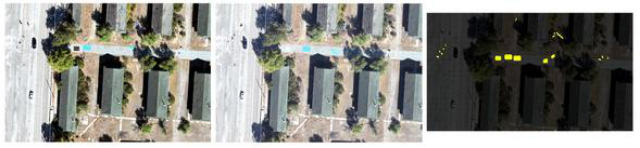
A computer programme compares the two images and does a highly advanced version of a “spot-the-differences” game, pointing out to researchers and officials where the images differ. These differences can highlight walls that have crumbled, ceilings that have collapsed, roads that have buckled, and other signs of infrastructure damage.
Several other SDSU researchers, students and graduates are also supporting the project. Electrical engineer Sunil Kumar is helping to determine how to optimize the wireless image and map transfer between ground control and the aircraft.
Geography graduate students Andrew Kerr and Manny Storey are involved in the project, and Christopher Lippitt, a graduate of the SDSU-University of California, Santa Barbara, joint doctoral programme is the institutional principal investigator for the University of New Mexico, which is collaborating with SDSU on the project.
Accounting for shadows
The key to all of this is being able to take clear photos from exactly the same place and angle, almost as if a camera was mounted in the sky, Stow said.
“The goal is for these images to look like they were taken by a stationary security camera, even though they were taken by an aircraft hundreds of feet overhead,” he said.
If all goes well and aircraft can be deployed quickly, Stow added, that information can be available to emergency responders within an hour or two after a disaster.
The tricky part from a computational perspective, he said, is accounting for ordinary changes that occur in a picture, such as the position of shadows or the location of cars in a parking lot. That’s a challenge Stow and his colleagues are currently working on.
Stow & Coulter
In the meantime, the researchers are working with San Diego County’s Office of Emergency Services, and its counterpart in Albuquerque, New Mexico, to run trials on simulated emergencies in order to optimize their software. Stow and Coulter are also developing a business, Repeat Station Imaging, through SDSU’s Zahn Innovation Center, which will seek commercial applications for their imaging technology.
“We think the UAV imaging market is about to explode,” Stow said. “Our technology can play an important role in its future.”
Photo: There are subtle differences between the first two images, captured by the computer programme pictured in the right-most image. Credit: Doug Stow and Pete Coulter.
Source: Phys Org