
 Laird Small is the longtime director of the Pebble Beach Golf Academy and has supervised the swings of tour players and celebrities and presided over the range at Pebble’s U.S. Opens and National Pro-Ams. He also helped design and outfit the Academy’s sleek new campus—which looks like a place you should get a lesson before spending $495 on a round of golf.
The shingled, Craftsman-style teaching facility is the nerve center for a double-sided range with turf more plush than the big course’s.
It also has what might be the most sophisticated collection of instruction technology in North America—including the arresting new $150,000 RoboGolfPro machine, which physically moves your club in the same pattern as any model golfer you choose while you hold on. Pebble has the first two in the United States.
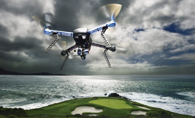
But when a Frisbee-size, four-blade mini-helicopter makes a lazy pass downrange before returning and hovering 20 feet over his lesson, Small and his student can’t help but do a double take.
“Amazing.”
Small’s aerial stalker is a drone—named after the remotely piloted military reconnaissance and attack vehicles that patrol the skies in trouble spots around the world. Even though the copters are evolutionary descendants of the gas-powered balsa-wood model airplanes hobbyists flew in the 1960s and ’70s, they have more in common technologically with their military namesakes. You can buy a consumer drone outfitted with four battery-powered motors and a gyro-stabilized video camera for about $1,000, and control it on your smartphone or tablet with a GPS-based system that was once available only to the military.
The pilot traces a route on the Google Maps-based app on his tablet screen, starting at the parking lot of the Golf Academy and cruising over Pebble Beach’s Lodge and down the beach adjacent to the 18th hole. It rises briskly to its pre-set altitude of 100 feet and departs, sounding like an amplified jar of agitated bees.
Four minutes later the copter returns, landing gently at the exact GPS-tagged spot from which it left. The tiny GoPro Hero3+ camera mounted to it’s belly recorded the spectacular mile-and-a-half oceanside trip in pristine high-definition without a hint of shake.
A 10-year-old could confidently fly the type of drone we’re using. Ask it to hover in a certain spot, and it uses GPS to lock itself in a loitering position, adjusting each of its four motors like a hummingbird to compensate for wind. From there, you can use the remote-control joystick to nudge the copter in any direction, or use a second stick to pivot and pan the camera.
Our pilot is decidedly more experienced. As 3D Robotics’ design director, Jason Short’s job is to figure out how to adapt the company’s copters to suit the ways consumers will use them. The wind is coming in hard off of Stillwater Cove, blowing straight into the par-3 seventh. It’s 106 yards, but today, a caddie tells a strong player that 7-iron is the club. Short’s mission is to hover the drone above the surf boiling the rocks at the base of the green, then fly it toward our photographer. The drone ably cuts through the 25-mile-per-hour wind, drawing stares from the foursome walking to the green. They can’t hear the drone’s motors in the wind, but it sure stands out from the seagulls.
The goal is to get the photograph on the first pages of this story—the drone flying against one of the most famous backdrops in golf. Short leans the drone into the wind to keep it steady for a few clicks of our camera, and then a fierce gust shoves the copter hard. One of the rotors catches the edge of the camera’s lens guard, and the drone pinwheels to the ground. The carbon-fiber propeller is a casualty, sheared off at the stalk.
The most popular consumer drones are all aimed at the same sweet spot of the market—a copter that’s intuitive to fly right out of the box and easy to upgrade with various cameras. Sturdiness is also important when you’re spending upward of $1,000 on a hobby vehicle. “I’ve crashed these things hundreds of times in testing,” says Short, surveying the underside of the drone. “They’re pretty durable. All of the money is in the middle: electronics, power supply, camera. I’ve never broken any of that stuff.”
Thanks to a vibrant aftermarket (and affordable 3-D printers), replacement and custom drone parts are easy to get—and getting more inexpensive by the month. The broken propeller is held on by a single bolt, and Short has a stash of $25 replacement pairs in the back of the cart. “The only thing you don’t want to do is go down in the water,” he says. “You won’t be getting it back.”

3-D course maps created by drone show elevation.
Courtesy of Dronemapper
Most hobbyist fliers use drones as platforms for amateur videography, so it will be interesting to see the uses golfers dream up. The allure of seeing your swing from above is obvious, as is making passes over your home course to get radically different perspectives. (Think filming your club’s member-guest playoff. An eye in the sky would not only preserve but intensify the drama for those not used to playing under pressure.) Flight time, however, must be a consideration. The hover feature built into the newest drones’ control software allows you to record about 10 minutes of a practice session from above. Of course, you’ve got know what to look for. Laird Small glances at the camera’s screen after the circuit above his lesson and laughs. The image reinforced his message—that the student’s club was laid off at the top. Networks like Golf Channel have already caught on, using industrial-strength drones to carry cinema-quality cameras on hole flyovers. It’s much more interesting to see that bunker 275 yards off the tee from the ball’s perspective. Even our basic low-level pass down the Pebble Beach range provided mesmerizing video of balls cycling through the frame on a green carpet of grass.
From a practical standpoint, drones can go where helicopters can’t, both in terms of proximity and cost. NBC used eight-rotor drones to chase skiers down the slopes at the Sochi Olympics. Movie directors use them for close-up aerial shots from positions where cranes can’t reach. Developers can survey large plots of land quickly, and park rangers can broaden their anti-poaching surveillance. One company is even testing a solar-powered drone that could stay up for five years, tracking global weather patterns.
Top-of-the-line drone rigs are completely handmade and can cost upward of $30,000, but when an hour of helicopter time—not counting the camera operator or video equipment—runs more than $2,500, the cost analysis starts to make fiscal sense. “You’re going to see them used more and more in search-and-rescue situations, and with fire departments—situations where you need more information from above,” Short says. “Railroads and oil companies have miles of track and pipeline that need to be inspected. Things that are dirty, dangerous or boring are great uses for drones, we like to joke.”
Golf is rarely any of those things, but the sport still makes a rich target for drone entrepreneurs. Colorado-based DroneMapper builds software programs that create densely detailed 3-D aerial maps. “Let’s say you have 100 images from the drone looking down onto your golf course,” says Jon-Pierre Stoermer, DroneMapper’s chief technical officer. “The software stitches those images together and translates them into a three-dimensional map, complete with topographical elevations. You can zoom right down and be the golfer on foot and see every leaf on the grass.”
The images are hyper-realistic, from the detail in rock formations to the slight curvature of the Earth. The images culled from satellites and traditional airplanes have a resolution of about half a square meter per pixel. The images produced by DroneMapper have a resolution of six square centimeters per pixel. In Google Maps, you can see the green. With DroneMapper, you can see the white of the lining in the cup.
Armed with that level of detail, a course operator can upload the data to its maintenance-control system and pinpoint the location of every sprinkler head. Other drone-mounted cameras measure reflected infrared light—a barometer of plant health—so superintendents can see which areas aren’t receiving enough water and light before the grass shows visible signs of stress.
Super-accurate topographical data will also provide a more direct benefit to players: course guides on steroids. Conventional yardage books and GPS-based guidance screens on carts provide “flat” distances, and even that information can be off by as much as five yards. “Drone-based maps can give an exact elevation profile of a hole,” Stoermer says. “Not only do you know how far it is between any two points, but what their relative elevations are.”
All that’s left is to pick the club and hit the shot.
You still have to do that yourself.
Source: Golf Digest