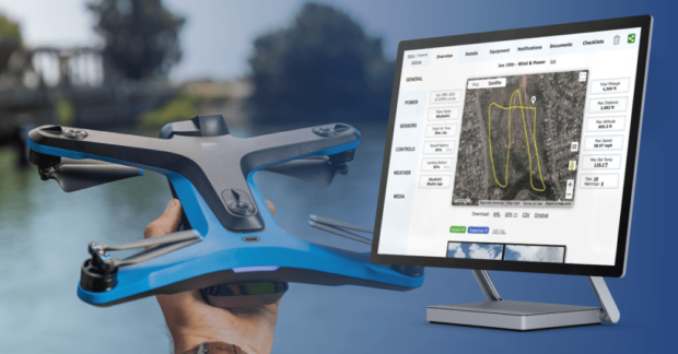
Airspace Link, Inc., a provider of drone mapping and solution software, announced it will be partnering with the City of Las Vegas to launch its new FLYSAFE program, powered by the AirHub platform. This program will enable drones operating in the city to fly safer today while paving the way for advanced commercial operations at scale. Continue reading
Category Archives: Software
Kongsberg Geospatial Releases TerraLens 9.3 Geospatial SDK
Kongsberg Geospatial has announced the general release of TerraLens 9.3, the latest version of their real-time, high performance, software development toolkit for geospatial visualization. Continue reading
ANRA Launches Risk Assessment Tool For EU and UK UAS Operations
ANRA Technologies UK Ltd, a provider of integrated airspace, mission management and delivery systems for uncrewed aircraft, has announced the release of SmartSkies SORA, a fully integrated Specified Operations Risk Assessment capability that enables pilots to perform a risk assessment for operations in the ‘specific’ category per European Union Aviation Safety Agency (EASA) regulations. Continue reading
Watts Innovations Releases PRISM Sky on Auterion Platform
The Watts Innovations PRISM Sky is now connected to the Auterion Suite, This heavy lift drone utilizes Skynode to integrate into the mission planning and flight software Suite for long duration flights, making it a drone with broad connectivity and integrated data workflows across inspection and mapping, spraying, cargo conveyance, LiDAR application, cinematography and more. Continue reading
Pix4D Appoints Exclusive Reseller for Mainland China
Pix4D has announced the signing of an exclusive reseller partnership with Beijing Skymap Technology Co., Ltd. a high-tech enterprise integrating software sales, service, research and development, and project integration in mainland China. Continue reading
AirData and Parrot Integrate and Partner
Parrot and AirData UAV are announcing a new partnership to benefit drone pilots and fleet operators. Parrot welcomes AirData to FreeFlight 6 through an integration with the AirData platform. The Parrot and AirData teams have collaborated to provide comprehensive crash prevention intelligence and live streaming to ANAFI pilots. Continue reading
Axon and DroneSense Partner on Drone Management Software for Public Safety
Axon a global supplier of connected public safety technologies and DroneSense, a software platform for drones in public safety, have announced a strategic partnership to provide public safety agencies with an end-to-end drone software solution, including piloting, administration, evidence management and live streaming. Continue reading
ANRA Technologies Launches Integrated Drone Delivery Platform
ANRA Technologies has announced SmartSkies DELIVERY, an end-to-end mobile and web-based software solution providing drone delivery services for commercial, government, and medical applications. The solution connects all the necessary stakeholders by providing the vital information and data exchanges necessary for safe, compliant, and efficient cargo and package deliveries. Continue reading


