
Avalanches occur in remote, hazardous terrain, making timely data collection difficult. Unmanned fixed-wing aerial vehicles offer a practical way to gather large-area imagery for mapping avalanche activity.
Researchers at ETH Zürich’s Autonomous Systems Lab present a proof-of-concept unmanned aerial system (UAS) that autonomously navigates and maps avalanches in steep alpine environments, aiming to enable efficient, large-scale monitoring.
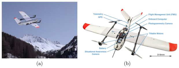
Accurate information on avalanche location and extent is vital for public safety, yet costly to obtain in inaccessible regions. Fixed-wing UAVs are well suited to this task due to their long range, speed, and low operating cost. However, autonomous flight in mountainous terrain is challenging because of complex topography, regulatory limits, and harsh weather.
The proposed system addresses these challenges through integrated planning and mapping strategies. Route planning is formulated as an orienteering problem, highlighting how mapping efficiency directly affects the number of regions of interest (ROIs) covered in a single flight. A safe path planner enables navigation that respects terrain, regulations, and the limited maneuverability of fixed-wing aircraft. An active mapping planner iteratively selects viewpoints to maximize information gain.
Field experiments demonstrate that the system can safely navigate steep mountain environments while producing high-quality maps. The vehicle maintained required distance constraints from terrain and successfully covered target ROIs. Results also revealed limitations, including brief constraint violations caused by elevation-map discretization and tracking errors.
Overall, this work shows that autonomous fixed-wing UAS can reliably operate in alpine winter conditions to collect high-quality avalanche data. Such systems could significantly improve avalanche warning, hazard mapping, and mitigation planning by enabling frequent, large-scale, and cost-effective monitoring.
The full study can be accessed here.