
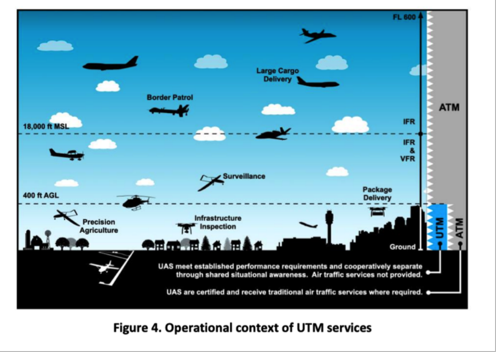
The systems required to safely coordinate unmanned traffic management (UTM) operations below 400 feet above ground level (AGL) between the Federal Aviation Administration (FAA), drone operators, and other stakeholders remains a work-in-progress.
According to the joint FAA and National Aeronautics and Space Administration (NASA) UTM CONOPS 2.0,“Integration of low-altitude UAS operations into the NAS presents a variety of issues and novel challenges.”
Vienna, Virginia-based ATA LLC, a full stack data science company, has plans to address these challenges on its home turf and beyond.
In partnership with the Virginia Department of Aviation, Virginia Center for Innovative Technology, and Virginia Department of Transportation, ATA helped create the VA-FIX, or Virginia Flight Information Exchange, the Commonwealth’s Authoritative Supplemental Data Service Provider (SDSP), to aggregate all relevant publicly available state and local data and publish it to industry and the public, as public data.
The Unmanned Traffic Management Concept
By way of background, the FAA and NASA envision a community-based and cooperative UTM system that will leverage industry to provide a federated set of services that will support UAS operators, facilitated by third-party support providers through networked information exchanges without FAA involvement or direct connectivity to traditional air traffic control.
In this system, the CONOPS says SDSPs will provide essential or enhanced services “including terrain and obstacle data, specialized weather data, surveillance, and constraint information.”
SDSPs will deliver this data through a distributed network of highly automated systems by way of application programming interfaces (APIs). SDSPs will use these APIs to connect critical data to those who need it in two ways:
- to area UAS Service Suppliers (USS), the communications bridges between various UTM stakeholders that will provide real-time volumetric airspace awareness data
- to drone operators through public or private internet sites or other means
The FAA has already approved several commercial companies as USS to participate in its Low Altitude Authorization and Notification Capability (LAANC). LAANC is a stepping stone to the larger UTM concept. It supports ATC authorization requirements for drone operations. It enables remote pilots to apply to receive a near real-time authorization for operations under 400 feet in controlled airspace.
How ATA Plugs Into the UTM Framework
ATA is both an FAA-approved LAANC USS and provides the key component of Virginia’s FIX SDSP, the AirDEX, the Commonwealth’s drone supplemental data API interface tech.
According to John Eberhardt, ATA’s Chief Technology Officer, with over 20 years experience in data science, which combines machine learning with decision support tools, in healthcare, commercial aviation, defense aviation, intelligence and logistics,
“What’s neat is that all of the data is governed by the Virginia Dept of Aviation, so it is all consistent and published in the same way. Think of it as filling in the aviation charts for UAS between 0 – 1,000 ft – a public aeronautical information system for UAS.”
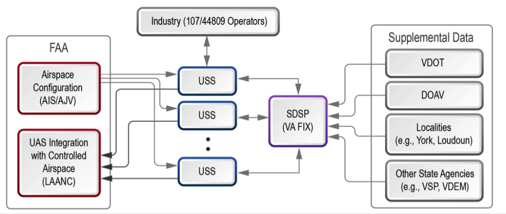
VA-FIX provides a central clearinghouse from Virginia state and local agencies to USS/UTM providers and from there to UAS operators
Value for Various Stakeholders
This comprehensive airspace awareness solution provides state and local agencies, including public safety, with:
- A web-based graphical user interface (GUI) that allows direct interaction with the system to publish, review, and analyze information
- A mobile web interface to publish advisories. This includes logic support to discover and publish intersection events and advisories
- Upload capabilities that tap into existing zoning and planning tools without being tied to them
- An API that allows state and local agencies, USS, and critical infrastructure providers to connect, share and retrieve data
The public safety component of AirDEX is both unique and significant. It provides public safety with a way to share information with each other, the public and private drone operators that clarifies the ground rules around public safety incidents. For example, public safety has used it to warn private UAS operators to avoid hazards such as chemical storage and infrastructure where a crash could result in explosion or loss of community services, to manage and coordinate operations in large crowd events and to coordinate operations post-disaster.
Another novel aspect of AirDEX is its incorporation of ground-based structures and public infrastructure, which would not otherwise appear on an FAA chart but could pose a hazard to unmanned aircraft such as radio and cellular towers, local critical infrastructure,and ground risks that are relevant to UAS. The ATA team works with the FIX User Group, composed of state and local agencies, private operators, and industry members to gather and characterize this data in the system.
Its authenticated API connections also enable any FAA-approved USS to correct, subscribe to, and share information to the FIX. Currently, seven of the FAA’s 17 LAANC USS providers are onboarded to VA-FIX and working with the Commonwealth of Virginia: Wing, Verizon Skyward, Aloft, Skygrid, DroneUp, ATA, and Airspace Link.
According to Craig Parisot, ATA’s CEO,
“We are focused on building partnerships across the UAS and AAM industries by pursuing open standards and frameworks. There is not a data provider, application developer, manufacturer nor operator with whom we can’t work,” said Craig Parisot, ATA’s CEO. “It is this type of collaboration and cooperation that will serve to accelerate the industry and increase technology adoption.”
For remote pilots, these USS interfaces seamlessly integrate through ATA’s ground control software to provide near real-time data for planning and operational decision making. It encompasses all Virginia state and local government information about supplemental local rules, authorized takeoff and landing areas, infrastructure and other local obstructions, terrain and obstacle hazards, public safety incident notifications, informational advisories and specialized weather data.
Finally, it provides a standard public web page that allows the general public to search and see unrestricted data. This supports public transparency, while protecting sensitive information.
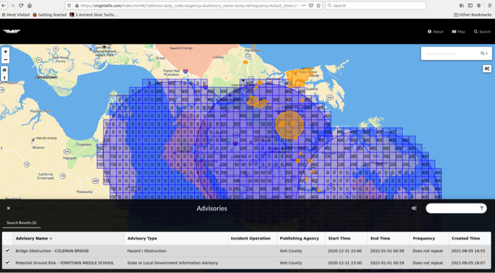
VA-FIX provides an additional layer of value added navaids alongside FAA configuration data – in Hampton Roads, it provides obstacles, obstructions, and public safety advisories to complement FAA airspace configuration data
The FIX Now and In the Future
Another unique aspect of the FIX is that, by law, it has become the authoritative source of UTM supplemental data for the entire Commonwealth effective 2021. House Bill 742 allowed local governments to regulate UAS take off and landing on public property. It mandated use of the FIX as the communication hub for government, industry and private operators.
According to Eberhardt, the process of bringing the various interest groups together to discuss data governance was one of the most valuable endeavors in which he had been involved. A former FAA contractor, Eberhardt gets it. He said,
“My biggest takeaway from the VA-FIX process is that industry and state and local government wanted to work together on this and they were ready. When we got all the different stakeholders in the room collaborating, we found that issues people thought were controversial could get worked out.”
And they did. FIX launched in August 2020 with 9 agencies and two advisories. A little over a year later, it has grown to over 40 agencies who have posted over 1,000 advisories.
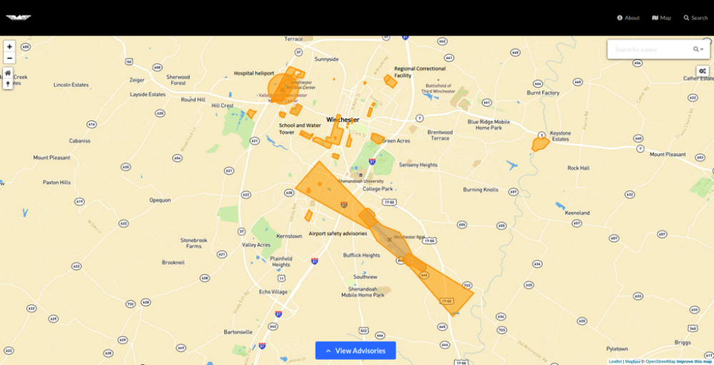
Local view of VA-FIX showing features of interest – a local correctional facility where an operator is prohibited from take-off and landing, hazards such as the local hospital heliport, airport safety guidance (published by the airport), and obstructions, such as the city water tower, which also occupies school property and is close to the approach patter for the airport
ATA now plans to take its lessons learned to other state and local governments to help people work together to accelerate the growth of drone ready communities. It expects to finalize an agreement with North Carolina soon, and several others thereafter.
“We’re working on some really interesting efforts to take the next leap in terms of integrating more stakeholders on public data infrastructure,” noted Eberhardt. “I think we’re a lot closer to all of this than people think. We are ready for the small UAS and Regional Air Mobility stuff. The technology is here, it’s relatively mature and people want these services. What we have learned is that building the network out isn’t as expensive as people think – if, and only if – you focus on working together in a federated model.”