
The Warragamba Pipeline delivers 80 per cent of Sydney’s water needs from Warragamba Dam
Keeping Sydney supplied with water means watching over many kilometres of pipeline. Thanks to drones and great troves of data, this company is making that task easier.
The biggest city in Australia gets 80 per cent of its water delivered through two pipes running above ground from a dam created at a narrow gorge in the Warragamba River.
Ensuring such vital infrastructure remains in top condition is a substantial task: at a length of more than 27 km, there is plenty of pipeline to succumb to cracks, leaks or corrosion. It should be no surprise, then, that the inspection and monitoring of this conduit — called the Warragamba Pipeline — is important and difficult work.
Traditionally, doing that work would require staff to go out in the field for manual inspections — a task that is both time-consuming and labour-intensive.
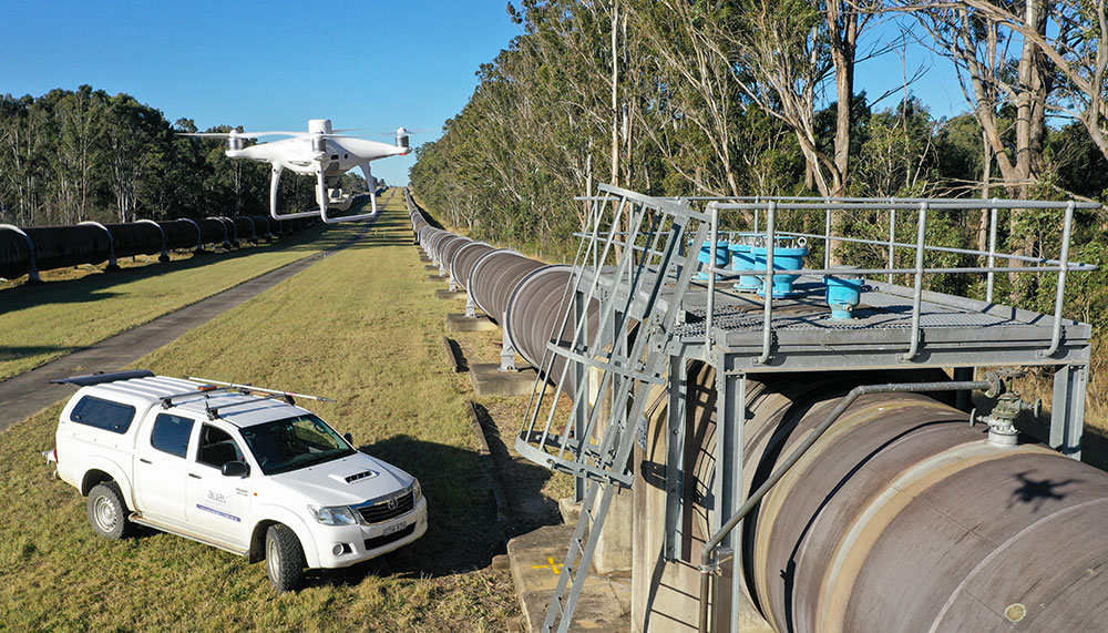
Enter Australian UAV, or AUAV, a Melbourne-based drone-service business that specialises in surveying, inspection and 3D modelling.
“This project was a challenge,” admits AUAV Director James Rennie. “It was definitely pushing the boundaries of large-scale data capture at a micro, micro scale.”
Over its past eight years of operation, AUAV has conducted more than 50,000 drone flights and become highly adept at handling large amounts of data. And modelling the Warragamba Pipeline meant handling an enormous amount of data.
“We ended up with 118,000 photos and that’s all at just over 20 megapixels,” Rennie said. “We’re talking terabytes of data.”
All that data was used to create a 3D model of the entire length of the pipeline that is accurate to a submillimetre level.
“Which is, in hindsight, a little bit bonkers,” Rennie said. “Really the technical challenges for this project were the volume of the data. So, projects on that scale, there aren’t too many of them around, and the ability to absorb that amount of data and then produce something which is incredibly useful for the client has been quite valuable.”
“We are observing that users of our software are adopting more capable drones, using higher resolution cameras, and also doing more mixed-mode capture where they process a combination of imagery and point cloud data,” he said. “This can result in a higher quality reality model compared with using each data source independently.”
The pipeline project, which was part of a broader multi-year maintenance project by WaterNSW, involved a number of different stages.
“The first part of the project was a high overview of the whole pipeline, and that one was processed so that we could separate the pipeline out and have a look at the surrounds,” Rennie explained. “Effectively a survey mapping type flight — so we might have been flying 50 to 60 m in that location and those photos then process up for that photogrammetric model.”
The complexity came with the next step.
“We were asked to get submillimeter pixel detail of all aspects of the pipe: top sides, undersides, all of the infrastructure surrounding the pipe,” Rennie said. “That was looking at a really high-level condition assessment of what is a current condition of that pipe. And then there, the engineers can look into that and do analysis on deterioration curves.”
Collecting the data involved preparing an approach that would be suitable for the specific idiosyncrasies of such a lengthy piece of infrastructure.
“There’s not a lot of texture or textural difference in there; you have to fly it in a particular way to be able to know that it’s going to stitch correctly when it goes in,” Rennie said.
“That was quite complex and, obviously, we’re flying in incredibly close proximity there. So that was a specific derived method.”
Future flights
AUAV’s work with WaterNSW was a one-off, but it sees potential for an ongoing relationship.
The data then acts like a time machine, allowing maintenance workers to pinpoint the exact time a crack first appeared or surface corrosion began to start.
“There’s obviously potential there to do a redo,” Rennie said. “A lot of our work is going back and redoing sites and then presenting that, and now we’ve got a tool where we can look at befores and afters or time-based differences.”
That also allows the information to be turned into training data sets for machine learning, Chapman said.
“You get more value from the data when you can do it on a recurring basis,” he said.
Spots of concern
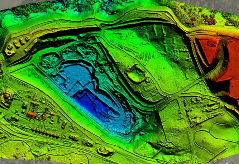
Engineers at the University of Newcastle have been experimenting with using drones to predict potential problem areas of pipes.
University of Newcastle’s drone experiments
The team uses technology called LiDAR — light detection and ranging.
“By attaching a device called a LiDAR to a drone we can accurately see where the lower lying areas are and, where land is not covered by buildings or concrete, we can also tell how wet the ground is,” said Associate Professor In-Young Yeo. “Our research promises to inform corrosion assessments of ageing infrastructure, allowing targeting of maintenance and replacements, and preventing expensive and disruptive breaks and leaks.”
By locating these wet patches, the engineers can target the nearby pipes for maintenance before they fail completely.
If the technique proves successful, the team hopes it could have other uses, such as monitoring wetlands or managing irrigation.
Source: Create