
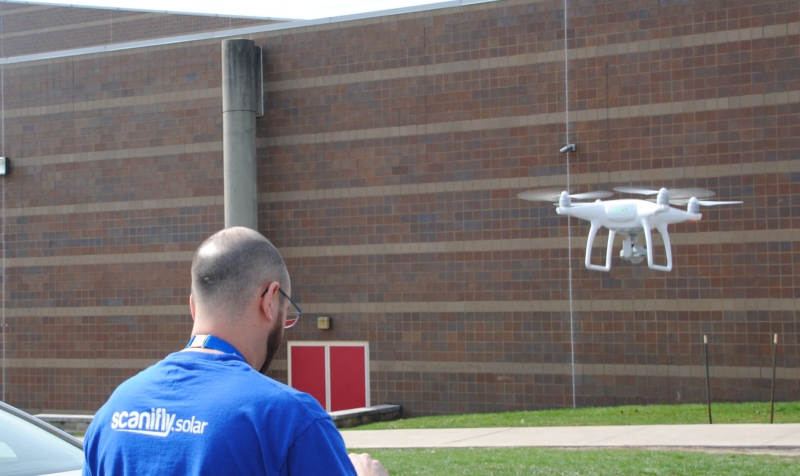
Innovative drone-based tools are substantially changing the solar workflow. Drones can help solar contractors collect on-site, real-time data without cumbersome tools like ladders and tape measures. They boost safety by avoiding roof climbs prior to construction.
Using drones and the right analysis tool, contractors can determine dimensions, pitch, azimuth, and automate the design process.
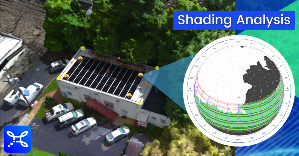
Now, using Scanifly technology, installers can also determine and submit solar shading analysis in most places across the United States.
Scanifly’s software is the only drone-based 3D modelling platform exclusively built for solar. The company’s team has decades of experience in solar, having done almost every job in the industry.
Nothing Compares to Capturing Onsite Data, a Vital Industry Practice
Earlier this year, in partnership with leading curriculum providers Solar Energy International (SEI) and NABCEP, Scanifly hosted a webinar series with 500+ attendees — mostly solar contractors — from over 50 countries and all 50 U.S. states. We used that event to understand where innovations like drone-based tools can best help.
 Asked about the accuracy of satellite imagery, 87% said it’s “OK” but always requires additional, onsite verification. We also learned that 98% of the solar industry visits project sites before construction — with more than one-third visiting before even closing the sale. As competition ramps up in local markets, this trend has grown, in part to maximize customer touchpoints and minimize reputation-damaging change orders.
When it comes to shading analysis, about as many people exclusively use satellite imagery (26%) as employ onsite tools (24%), while even more use a combination of both (29%). This points to the value of an initial design as well as the importance of a comprehensive final layout based on an onsite solution. When done manually, onsite shading tools can provide accuracy, but they still pose challenges for working safely and efficiently. Drone-based applications provide the best of both.
Furthermore, many solar contractors provide production guarantees, some as high as 90%. Fulfilling guarantees like this requires impeccable accuracy. An incorrect system output forecast can be fatal for a company’s solvency. Incorporating even greater precision (e.g. exact tree heights, vent pipes, adjacent buildings) into the system design and crafting a virtual replica, to-scale environment that only a drone can create is even more vital to a company’s success.
Scanifly’s global solar software, which is built on proprietary drone-based 3D modelling technology, includes the only drone-based shading analysis tools to be approved by regulators and lenders as bankable.
Scanifly’s New Shading Tools
Within the past few months, Scanifly has achieved significant breakthroughs as it relates to shading analysis:
First, Scanifly was certified by the California Energy Commission as the only drone-based tool for shading in the Golden State. California’s Title 24, Part 6, says that all newly built homes must have solar. Scanifly’s solution is essential for California’s CF2R Solar Access Verification process, which requires a “solar assessment report must be created after the installation,” including real-time imagery.
Second, Scanifly created the industry’s first horizon shade-analysis tool with a panoramic simulation of the real-world surrounding environment. This shading product satisfies additional financing requirements and provides a virtual view of the surrounding area.
Before these recent achievements, Scanifly already had been validated in New York, Massachusetts and Texas. Last year, Solar Power World reported that NYSERDA and MassCEC validated Scanifly as the only drone-based tool in New York and Massachusetts, respectively. Austin Energy and other regulators have also validated the software.
Scanifly’s shading tools are proven to be within 1% of the Solmetric SunEye, another onsite shading tool. This comparison was required by state agencies and documented in a case study. The software has also been proven to be equal to, if not more accurate, than satellite imagery-based tools.
Scanifly’s drone-based 3D modelling tools allow solar professionals to quantify shading, including determining solar access values, TOF and TSRF, which factor into shading losses and production analysis. The software also has a qualitive shading simulation that can be visually informative.
COVID-19 and Solar
Despite a challenging year with COVID-19 and its economic impact, the solar industry remains resilient. While COVID has motivated solar contractors to promote remote selling, in many cases this has not replaced the need to get a real-time view of the site. Anecdotally, we have heard of portfolio redesigns due to satellite imagery limitations as high as 75%. An onsite assessment also provides another touch point to further cement strong customer relationships.
Drones provide the right balance of speed and accuracy, while respecting social distancing. (See this previous article, “Three ways to improve your solar business during COVID-19.”) They also provide fantastic imagery to help close more sales and show a to-scale 3D model of the solar project.
With the challenges of 2020 and the opportunity for growth in 2021, shading analysis tools like Scanifly that leverage drone data to simplify and improve solar project planning are poised to play a significant role in the industry’s acceleration.
Source: Press Release