
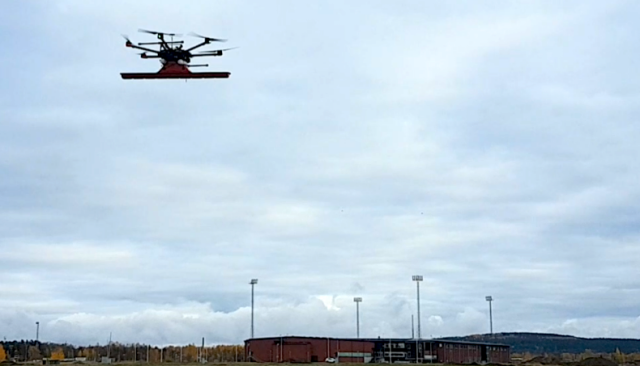
To bring technically advanced solutions for surveyors, land engineers, researchers, rescue service providers and sappers – SPH Engineering – the developer of leading drone mission planning software UgCS and Radarteam Sweden AB – the manufacturer of Ground Penetrating Radars completed test flights combining Unmanned Aerial Vehicle (UAV, drone) and GPR technologies.
For the test, a Radarteam Sweden AB Cobra Plug-in Ground Penetrating Radar with SE-70 antenna and penetration of 80 m was integrated with DJI M600 drone.
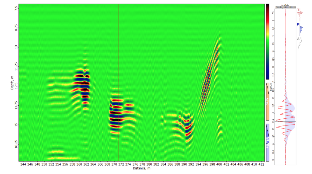
Processed underground data acquired with a drone equipped with Ground Penetrating Radar (GPR)
GPR is a geophysical method using radar pulses to image the subsurface. As displayed in the processed data image, during the test flight over an abandoned area some objects were detected in 10-16 m depth with the drone flying on 5 m AGL altitude.
“A GPR installed on a drone enables to see through the surface of ground, ice, rocks and buildings or through structures at unsafe and hazardous environments without compromising the safety of staff, providing an additional solution for more efficient surveying” added Per Wikström, Radarteam Sweden AB CEO/ Managing Director.
The information and results acquired during the test flights will be put together to develop best practice recommendations for the use of GPR installed on a drone and flight mission planning in UgCS to acquire usable data for post-processing.
“UgCS has proven to provide sophisticated tools for professional UAV surveyors to acquire data with diverse camera types, LIDAR or towed magnetometers. The list of drone applications is expanding with every day, so the development of UgCS has to be one step ahead – therefore experienced team members of SPH Engineering and Radarteam Sweden AB joined forces to researched the not so usual combo of a drone and a Ground Penetrating Radar (GPR) to create guidelines for its usage,” informed Janis Kuze, SPH Engineering Sales director.
Source: Press Release
Hi,
1. What sizes of items this device can find.
2. There are topographic limitations like slopes.
3. Is there a problem to go through massive vegetation.
Thanks
Yoav
Yoav,
You might like to contact those involved,i.e. UgCS and Radarteam Sweden AB, for more information…
Yoav,
did you have any information regarding this project? Could you please share if so.
Todah
Asaf
Will this detect gold meteorites ?
Hello
I want to ask ask what kind of detection does the drone detect.
And what is the weight of the GPR on the drone.
Saif,
Please see my earlier reply to Yoav:
You might like to contact those involved,i.e. UgCS and Radarteam Sweden AB, for more information…
Is 5m the best hight for data collection, what is the software used in post production of the data, does it include grid slice
David,
I suggest that you start by contacting SPH Engineering by clicking on the link in the article…
(Sorry for the delay – notification of your post went into Spam folder)
do you sell? cost? please send to my email
Christian,
I suggest that you contact the manufacturer, Radar team, by clicking on the link in the article…
Do you sell this? please send me costs
thanks
That is cool. I am using 4.5 to 5 gig microwave for my drone scanning ground scanning radar. What frequency are they using?
James, I suggest that you click on the link in the post to Radarteam Sweden AB – the manufacturer of Ground Penetrating Radars and contact them directly…