
Michael Wing, director of Aerial Information Systems Laboratory at OSU , left, and doctorate student Cory Garms – Andy Cripe – Gazette-Times
Since he began using unmanned aircraft in his research in 2012, Oregon State University forestry professor Michael Wing has seen many ways a flight can go wrong. Once, in August, he even had a turkey vulture threaten to attack a quadcopter he was using; the bird came within about 15 feet of the vehicle, he said.
Wing said nearly every flight has some kind of complication.
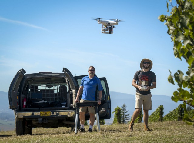
Wednesday, when Wing and one of his graduate students surveyed a vineyard near Amity, was no exception.
On the first flight, Wing and his student, Cory Garms, briefly lost control of the quadcopter they were using to record infrared footage of a vineyard as the craft’s battery was ticking down to near zero. The vehicle, which was following a programmed route, kept trying to follow the route even as Garms was attempting to take manual control of it to land it as the battery was getting low.
Garms eventually was able to get control of the craft and land it with about 10 percent of its battery capacity remaining. That’s well below the 25 percent he and Wing aim to have remaining when they land, so that they don’t risk thousands of dollars of equipment falling out of the sky when the battery dies.
Wing said that despite the challenges, lots of new research opportunities are made possible by vehicles like quadcopters and other remote-controlled vehicles equipped with cameras, infrared sensors and LIDAR systems to do survey work. Wing said before these crafts were available, it took six months to schedule a plane to do a flyover to gather similar data.
Although when he started using unmanned vehicles for survey work, the Federal Aviation Administration required a two- to five-month process for approval of such research flights, Wing said that process was streamlined in August 2016.
“We went from one flight in 2012, to two flights in 2013 and from there it just exploded,” he said.
Wing said the 2012 flight was the first FAA sanctioned research flight in Oregon, but there are now 15 to 20 other researchers at OSU alone using unmanned aerial vehicles for research.
He said his Aerial Information Systems Laboratory at OSU has a budget of anywhere from $30,000 to $50,000 annually, and gets funds from the U.S. Forest Service, U.S. Fish and Wildlife Service, Oregon Department of Fish and Wildlife and Oregon Department of Forestry. Wing is also the principal researcher for OSU’s participation as a core university in the FAA’s Center of Excellence for Unmanned Aerial System Research.
Wing and his students have done projects like surveying a shipwreck, counting sea turtles, studying elk populations and doing topographical studies of volcanically active areas. These studies have taken place across the United States and in Indonesia, Brazil, Turkey, Germany and the Dominican Republic.
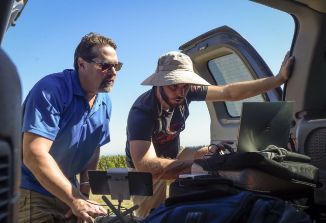
Wing and Garms check data from drone flight
Wednesday at the vineyard near Amity, Wing and Garms were surveying a field where the grapevines had been infected with red blotch disease, a viral infection that hampers fruit production. Wing said the flight was the fourth in a series of five monthly flyovers at the field where he and Garms were using an infrared camera to look for the disease. Wing said that they are testing whether the infrared camera can detect the disease earlier, because the cameras can see shades of red on the grapevine leaves that the human eye cannot see.
Wing said he and his team will need to confirm the presence of the red blotch virus with genetic testing and have months of data analysis to do, but early signs are that the method is promising.
“Hopefully, this would allow (vineyard owners) to know there is a problem earlier,” he said. “Potentially, this could be a really valuable tool.”
Wing added that there aren’t any treatments for red blotch disease except containment, so an early detection method could help vineyard owners keep healthy plants from getting infected.
Garms, a doctoral student, said he thinks someday there likely will be companies that travel around hiring out drone surveying services for vineyard owners. He said he’s thought of doing that kind of work himself when he finishes his studies.
“In the future, this could be as common as having your soil tested,” Garms said.