
 There is nothing really unique about someone making drones, but Moses Gichanga Mwaura is doing it for a different cause – to save our wildlife. Armed with a laptop installed with specialised software he has developed, Mwaura , 31, controls an unmanned aerial system commonly known as drones, which are designed using locally available materials to carry aerial surveillance.
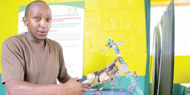
He believes the technology can help save wildlife from the gapping jaws of poachers besides offering solutions to other social problems facing the nation. From his laptop, Mwaura operates a tiny light aircraft the size of an eagle, which he designed using a combination of locally available material including plastic, fibre glass and resin.
The tiny plane is camera and GPS enabled and while airborne it can capture a series of aerial images and videos and store records in its installed internal memory.
“The technology operates in such a way that a person controlling the system uses a software, which I developed to select coordinates from the computer programme to create a flight path you want the plane to follow,” says Mwaura, the founder and CEO of Contrail Robotics.
The programme is a computer user interface developed using NASA world wind maps, creating a beautiful virtual earth that literally makes one view the whole world on a computer in 3D version. With specific coordinates of an updated map of a targeted area set properly, it is an idea Mwaura believes can be implemented in the country and help fight crimes in the parks by exposing poachers and their activities.
“Now suppose you are a KWS or KDF officer planning to carry a border patrol to pursue terrorists or poachers, what you need to do is to select your coordinates and let your plane fly. You can zoom in and out your area of focus to find out whether there are features like mountains or tall trees along your flight path.
From there you can comfortably reset your coordinates and change your altitude to ensure that your plane doesn’t crash on mountains or forest,” explains Mwaura. Images being captured by the drone can be instantly viewed through a partitioned monitor panel at one corner of the same computer being used for controls.
There are various versions of the programme, which can be installed in various devices including a mobile phone. This makes it possible to operate the system from vehicles, a room or even from a mobile phone. “It can be installed in any device. For outdoor users they can use cellphones.To operate the system one requires basic computer skills,” he said.
And to keep cyber criminals at bay, Mwaura says he has used various encryptions that make it virtually impossible to break the system and sniff the data being conveyed from the air to the ground, by jumbling the signals such that any attempt to hack the data will make the signal collapse.
Using the system, he says in 2011 he successfully took several aerial photos of a herd of elephants grazing in the expansive Tsavo National Park, an achievement he says confirms the viability of his project. He is urging the government to adopt it to help end widespread poaching activities in the parks.
A similar technology, he says, can be applied in carrying out agricultural research activities and help Kenya shield its citizens from pangs of hunger using Normalised Difference Vegetation Index (NDVI)- a simple graphical indicator that can be used to analyse and determine the density of live green vegetation on a patch of land.
Mwaura, however, says bureaucracy within the government system has made it difficult for the project to make a breakthrough. Mwaura, a computer science graduate from Multimedia University, says he developed an unswerving passion for aeronautical science as a child.
“I never learnt this; I started it out of boredom and designed simple planes and later developed it adding motors, and later cameras then sensors and now it’s a full computerised system,” says Mwaura.
He singles out building transponders – a device for receiving a radio signal and automatically transmitting a different signal, sensors and radar systems which can be recognised by the Kenyan Civil Aviation Authority for security purposes, as some of the main challenges enshrouding his project and notes that the drone would cost around Sh100,000 to make were it not for the cost of the radar and transponders.
He reckons that the cost will be pushed to around Sh1.5 million with the purchase and fitting of all the needed systems, adding that mass production of the drones locally will be cheaper than importing them.
Source: Media Max
I have liked Mwaura’s passion in the drone making. I too try to develop them but from a different perspective. Most drones even from the developed countries do no last long in the flight due to the battery energy getting used up within minutes or at most an hour. However, I am in the process of making shock free, high speed, and ever lasting engine-powered drone. That is just a summary, it is more complicated from its hardware, control systems, extra precise positioning, and stabilization, as well as four programs that I am developing to fully make it a self-driven drone (switch from manual to autopilot).
Anyway, big up Mwaura and thank you for trying to save our wildlife.
Regards.