
 Just in time for this year’s hurricane season, the National Oceanic and Atmospheric Administration will be upgrading its Coyote drones for storm research and climate data collection.
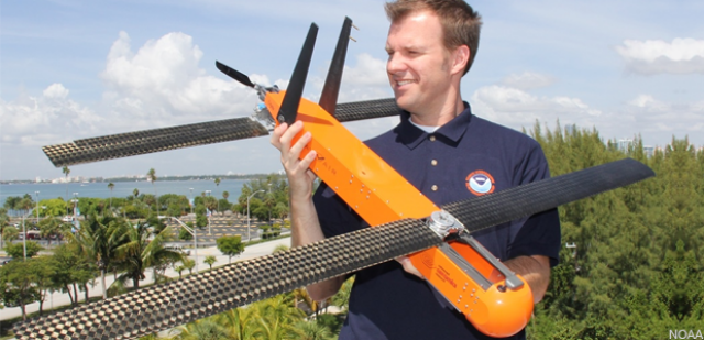
Raytheon will deliver three unmanned aerial systems with improved communications and integrated metorologic sensors for storm research. The Coyote unmanned aircraft, at only three feet long and between 12 and 14 pounds, can carry either electro-optical or infrared cameras and data transmitter payloads. They are capable of speeds between 60 and 85 knots and a ceiling of 20,000 feet.
Dropped from a free fall chute in the belly of the plane, the Coyote is designed to then open its six-foot wingspan and fly through the storm, according to NOAA. It can be controlled from miles away, but is usually piloted by scientists onboard nearby planes. Its lightweight design means the Coyote flies with the wind currents, but it can be directed horizontally and vertically to measure the storm’s activity at the lowest altitudes.
Last year NOAA dropped four Coyote drones directly into the eye and surrounding eyewall of Hurricane Edouard, providing scientists with continuous pressure, temperature, wind and humidity data from the critical part of the storm. “Flying this thing around in those high winds for an hour, we are much more likely to capture what that maximum speed is,” NOAA hurricane researcher Joe Cione told the Guardian. “That’s important because that’s what the forecasters use to warn people to get out of the way.”
While NOAA has historically used manned aircraft for hurricane observations, Congress appropriated funds for the unmanned systems after Hurricane Sandy in 2012 in order to better understand and evaluate storm systems. This funding was especially important because the Coyote UAS can collect temperature, pressure and wind observations below 3,000 feet – an area in which manned aircraft cannot safely operate. In addition to expanding the Coyote’s mission this hurricane season, NOAA will also use the Global Hawk to gather data to improve forecasting a hurricane’s intensity and track.
“Flying the Global Hawk with weather observing sensors above a storm is like putting the storm under a microscope. We can gather high resolution data to see more clearly inside the storm and better capture changes in wind speed and intensity,” said Robbie Hood, director of NOAA’s Unmanned Aircraft System Program, alluding to the near-space altitude of 60,000 feet the Global Hawk is capable of achieving for up to 24 hours of continuous flight. “We are also testing how unmanned aircraft can be a reliable observation tool to augment weather observations from satellites.”
Source: GCN