

The FAA has announced a smartphone application that aims to make it clear to Unmanned Aerial Vehicle (UAV) enthusiasts where it’s legal to fly in the National Airspace System (NAS). The B4UFLY app, announced at the 2015 Association for Unmanned Vehicle Systems International (AUVSI) Conference in Atlanta, Ga. will allow hobbyists to determine whether there are any restrictions or requirements in effect at the location where they want to fly a UAV.
“It’s a simple, easy-to-use app that answers a very basic safety question: is it safe and legal to fly my unmanned aircraft at a particular location?” FAA Administrator Michael Huerta explained to journalists during a press 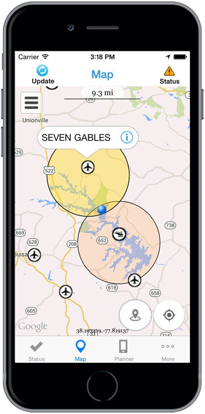 conference for the roll out of the new app. “Longtime members of the unmanned aircraft community may already know the answer to that question. Someone who got their first unmanned aircraft as a gift under the Christmas tree probably doesn’t. That’s a knowledge gap we need to fill.”
That’s a knowledge gap we need to fill. The United States has the most complicated airspace in the world. We need to make sure hobbyists and modelers know where it’s okay to fly and where it isn’t okay to fly – because there can be very real consequences if you don’t. The incident on the White House lawn earlier this year is a good example.
We plan to make B4UFLY available to approximately 1,000 beta testers using Apple devices this summer, and we’ll be working on an Android app in the future.
The B4UFLY app is the latest action the FAA has taken to encourage the responsible use of unmanned aircraft. In December, we partnered with the Academy of Model Aeronautics, the Small UAV Coalition, and our friends here at AUVSI to launch the “Know Before You Fly” campaign. This was an important first step in educating operators about the rules of the sky.
The B4UFLY app takes a lot of that information and puts it right in your pocket – available to use anytime, anywhere. It only takes a few taps to find out if you’re cleared to fly. While other resources like this exist, we believe B4UFLY will have the most user-friendly interface with the most up-to-date information.
The agency is planning to release the app to an estimated 1,000 beta testers during the summer. Limited beta tests are expected to run for several months, after which the FAA will make the app available to the general public on Apple iOS devices, with an Android version to follow.
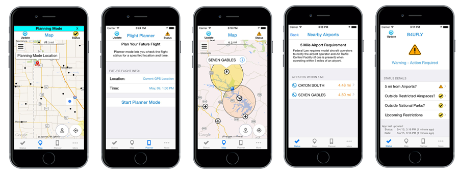
Key features of the B4UFLY app include:
- A clear “status” indicator that immediately informs operators about their current or planned location.
- Information on the parameters that drive the status indicator.
- A “Planner Mode” for future flights in different locations. Informative, interactive maps with filtering options.
- Contact information for nearby airports.
- Links to other FAA UAS resources and regulatory information.
click to enlarge
The app features interactive maps and a clear status indicator that immediately informs the operator about the area surrounding their current or planned flying location. For example, it would indicate that flying in Special Flight Rules Area around Washington, D.C. is prohibited and other similar restricted flight areas. It also provides information on such parameters that may restrict airspace, contact information for nearby airports and links to other FAA UAS resources and regulatory information to keep operators updated to the fullest extent.
Source: FAA