
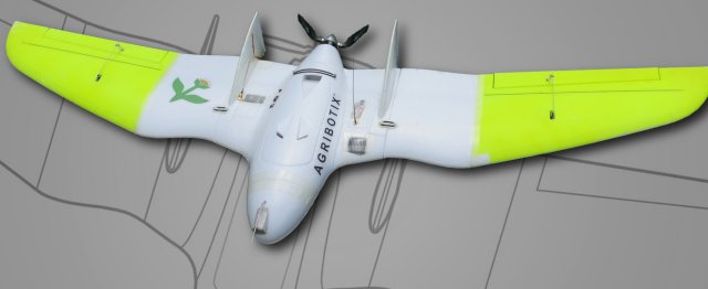
 Boulder, Colorado-based Agribotix is helping farmers save money and conserve water and resources in a new way: by flying drones over their fields to measure crop density, growth and many other factors.
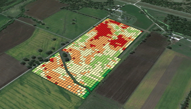
Agribotix, founded last year, works with farmers in Colorado like this: They send up drones over a field, fly over and capture photo, infrared and other data, and then land after about 20 minutes. The data is then transformed into maps showing where the crops are thriving and where they aren’t.
Speaking at the Innosphere, a northern Colorado incubator for clean tech, tech and life sciences, Agribotix CEO Paul Hoff explained that the company’s drone solution would help save both money and conserve resources.
One case study: Agribotix was working with Munson Farms, a 4,000-acre corn farm in Missouri. By gathering the data from the drones, farmers were able to determine what parts of the field needed fertilizer and which didn’t. Simply looking from the side, the farmers couldn’t tell everything about growth. But after Agribotix developed a Management Zone map based on near-infrared imagery of plan density (!), they could see where the plants were chest-high, and which were waist-high.
For a farm that usually uses 50 tons of fertilizer per acre, they cut it down by 40 percent.
What data does in agriculture is allow for the prevention of waste. As you probably already know, American agriculture is incredibly resource-intensive, especially dependent on petroleum products that are manufactured into nitrogen-rich fertilizer. Water use as well is incredibly intensive: According to the USDA, more than 80 percent of water used in the U.S. goes to agriculture, with as much as 90 percent in Western states like Colorado. It is hopeful that simply getting more precise about irrigation and resources would ease demands on many fronts at once.
In other example, drone information helped a client avoid sacrificing their entire crop after a hailstorm. Assuming the whole field would have to be written off, the drones found that hail had really only damaged a section of the field, and the rest could keep growing.
Agribotix is going open-source with its “Bring Your Own Drone” project, which is open to the public and available at a discount. It’s a set of tools that make the critical link between the data collection and the production of maps that farmers can actually use for their planning.
Source: Triple Pundit