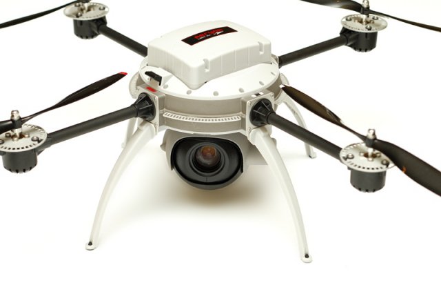
Energy companies have been testing small, unmanned aircraft as potential pipeline and drilling rig monitors. After the government, no one is as interested in unmanned systems as the energy industry. (The Interior Department has more than 40 unmanned aerial systems that it uses to monitor wildlife and fires.)
Many of the major energy companies — including BP PLC, Royal Dutch Shell PLC and ConocoPhillips Co. — have been eyeing the technology for everything from pipeline surveillance to disaster response.
Greg Walker, manager of the University of Alaska’s Unmanned Aircraft Program, who has worked with companies to test the systems for monitoring pipelines, said current technology would allow flights over hundreds of miles of infrastructure to look for erosion or leaks.
“I could sit here in Fairbanks, which is about in the middle of the 800-mile Alaskan pipeline and fly south to Valdez or north to Prudhoe Bay on an almost daily basis looking for hazards,” he said. “The planes that would do that today weigh about 40 pounds, are gas-powered and fly for about 20 hours at a time.”
Companies currently do such surveys with manned helicopters that average about $300 an hour to operate. Making the transition to unmanned systems could bring major savings and a lower carbon footprint.
Then, there are the places unmanned aircraft can go where humans cannot.
In November 2011, Walker aided a BP test at an oil field in Prudhoe Bay where the company runs a basic crude processing operation that burns off extra gas. The pilot flames are about 3 to 5 feet tall, he said, but when the gas flares, the flames can jump as high as 300 feet in a matter of seconds.
Every few years, the company shuts down the operation for maintenance, but because the flaring area is so dangerous, it cannot send people or aircraft in ahead of time to find out what parts of the infrastructure need repairs.
“They can’t go in there to look at the flares until they shut them down, so they don’t know what parts to order,” Walker said. “Do you order everything in advance and then show up and not need it? Or do you wait to get there to order what you need and then have to express [ship] it all?”
Using BP-owned Aeryon Scouts, which weigh 2.5 pounds and look like smoke detectors with helicopter blades, Walker was able to take pictures of the flares while they were burning — something he said the company’s workers had never seen before.
The energy industry and other groups also are relying on unmanned aircraft to keep an eye on wildlife.
In an early energy industry-drone experiment in 2008, Walker teamed up with Shell to test whether unmanned aircraft systems could help monitor wildlife in offshore areas where the company planned to work. Part of Shell’s permit requires the company to halt its seismic surveys if whales or other protected wildlife are nearby, and Shell wanted to figure out the best way to watch for the animals.
“This is something that’s traditionally done by putting marine mammal observers up into the sky with planes,” said Mitch Winkler, Shell’s Houston-based Arctic technology programme manager. “What we see as the opportunity here with unmanned aircraft is moving these marine mammal observers from the sky and putting them behind work stations.”
Operating from a research vessel in the Beaufort Sea, the team used Scan Eagles, systems that weigh about 40 pounds and have been employed by the U.S. Navy. Both Walker’s team and Shell said they were pleased with the project, although unrelated permitting issues ultimately prompted Shell to put the work on hold.
Federal agencies are also discovering the benefits of using the systems to monitor wildlife. In 2009, scientists with NOAA used unmanned systems to survey ice seals in areas of the Bering Sea that are difficult to reach with piloted planes.
There, the drones’ stealth proved to be a plus. Some flights were so quiet they brought back pictures of seals at rest, said Robyn Angliss, deputy director of NOAA’s National Marine Mammal Laboratory in Seattle. That lets scientists take better counts and leaves sensitive species undisturbed.
“We don’t have a reliable estimate of ice seals right now, so being able to do this is pretty important,” Angliss said.
Now, Walker is being tapped to put his aircraft to use in resolving a long-standing dispute between NOAA and Alaskan fishermen over fishing restrictions related to the endangered Steller sea lion. NOAA has placed catch limits on fish in the species’ food chain near Alaska’s Aleutian Islands. But the fishermen argue the species’ declining numbers have nothing to do with food shortages.
Both sides hope Walker can collect better data on the issue. Population counts are currently taken using manned aircraft that fly to a handful of locations where sea lions have been known to congregate in the past. But bad weather can limit flights and render photos useless, and the method does not account for animal movements.
Working with NOAA scientists this summer, Walker will fly his systems below cloud cover along broad swaths of the coastline, counting animals and looking for clues about what is affecting their health.
Source: Environment & Energy News

