
MnDOT’s efforts to study whether drones can help bridge inspectors are progressing, and the second phase project has been completed. (Meanwhile a third project has just begun.)
Phase 1 of this research project demonstrated that drones can reduce safety risks and inconvenience to bridge inspectors and the traveling public. Phase 2 shows that new drones, designed with vertical and horizontal camera and sensor capabilities for structure inspections, give bridge inspectors safe access to under-deck areas that were previously difficult or impossible to reach. The new drones cost even less than the unit tested in Phase 1.
“Using a drone rather than snoopers for bridge inspection can save significant time and cost. The FHWA approves of this use as well. It’s another tool for inspectors to employ,” said Jennifer Wells, Principal Engineer on Mobility, MnDOT Office of Bridges and Structures.
“We were one of the first transportation agencies and contractors to test and use this new technology for bridge inspections. Drones let bridge inspectors collect more data and collect it more safely and efficiently,” said Barritt Lovelace, Regional Manager, Collins Engineers, Inc.
What Was the Need?
MnDOT and local bridge owners have 600 bridge inspectors who monitor more than 20,000 bridges in Minnesota. Each bridge must be inspected once every 24 months. Bridges in poor condition and those considered fracture-critical (where failure of a single component could cause collapse) must be inspected every 12 months. Large bridges can take weeks to fully inspect and often require inspectors to dangle from ropes or stand in buckets on the end of “snoopers,” cranes that reach from the bridge deck to below-deck level to put inspectors within sight of under-deck elements.
Snoopers are expensive and require traffic lane closures, presenting safety risks to the traveling public and inspectors. MnDOT established in a Phase 1 study that unmanned aircraft systems (UAS) significantly augment inspection findings with infrared and imaging data while reducing safety risks to inspectors and the public. The project earned a 2016 Minnesota State Government Innovation Award as well as awards and recognition from such groups as the American Public Works Association.
UAS designed specifically for structure inspections were unavailable during Phase 1. The UAS used in that phase had key operational limitations, including the inability to proceed when concrete and steel bridge components blocked Global Positioning System (GPS) signals. When that happened, the drone simply returned to base automatically.
What Was Our Goal?
In Phase 2, MnDOT wanted to test the use of an upgraded UAS to examine larger and more challenging bridges. The new UAS, which was specially designed for structure inspections, featured more robust imaging and infrared data-gathering capabilities, and was more flexible to control. Its operational capabilities also were not diminished by the loss of GPS signals. Results from UAS inspections and traditional bridge inspection methods would be compared for quality and cost-effectiveness.
What Did We Do?
Investigators selected a prototype senseFly albris UAS to inspect four bridges:
- The Blatnik Bridge over the St. Louis River between Duluth, Minnesota, and Superior, Wisconsin, a 7,980-foot-long steel through-arch bridge with steel deck trusses.
- A 362-foot-long two-span steel high truss bridge over the Red River in Nielsville, Minnesota.
- A 263-foot-long corrugated steel culvert in St. Paul.
- The Stillwater Lift Bridge, a 10-span structure over the St. Croix River with six steel through-truss spans and one movable span.
For each bridge or structure, researchers prepared detailed safety and inspection plans to identify and mitigate potential hazards, inspection needs and Federal Aviation Administration (FAA) requirements. Researchers conducted and evaluated UAS and standard inspection methods for each inspection site, analyzing results in terms of access technique, data collection and usefulness for interim and special inspections.
What Did We Learn?
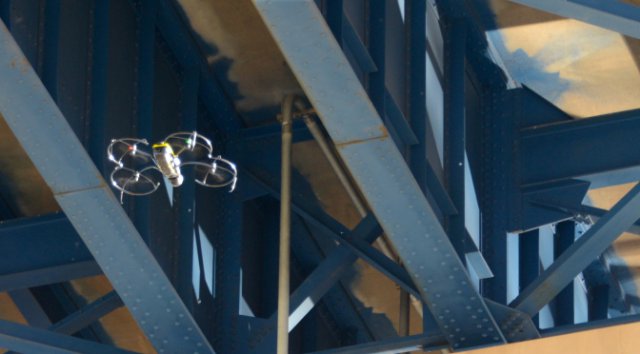
The senseFly albris UAS offered a clear operational upgrade over the Phase 1 unit. It can operate without GPS; the camera lens can turn up and down at 90-degree angles; and protective shrouds and ultrasonic sensors prevent the propellers from striking bridge elements.

For some inspection functions, lane closures can be curtailed or eliminated altogether. The drone worked well in the high, confined spaces of the Blatnik Bridge and should provide under-deck inspection details otherwise unavailable or too costly for any tall bridge in the MnDOT system. This UAS identifies and measures clearances, rope access anchor points and other pre-inspection conditions for planning large-scale or emergency inspections. Photogrammetry software can be used with the UAS to develop three-dimensional models of bridges and bridge sites. Using infrared thermal sensors, the UAS can detect delamination of concrete while flying adjacent to lanes of traffic. For smaller, confined spaces on bridges and culverts, the senseFly albris may not be ideal. Despite its protective shrouds, it is not as collision-tolerant as needed for very tight spaces.
Currently no UAS replicates hands-on inspection functions like cleaning, sounding, measuring and tactile testing. But the UAS is an additional tool that provides conventional and improved data safely. The FAA and the MnDOT Office of Aeronautics no longer require private pilot certification for drone operators. A new, streamlined certification and licensing procedure makes drone use more practical.
Costs were significantly lower with UAS inspections than with conventional approaches. Conventional inspection of the Blatnik Bridge would have required four snoopers, an 80-foot lift and eight days of inspection, at a cost of about $59,000 (without the cost of mobilizing equipment and traveling). The UAS Blatnik Bridge inspection would contract as a five-day, $20,000 project.
What’s Next?
Phase 3, which began in the summer of 2017, uses the senseFly albris and the Flyability Elios, a collision-tolerant drone more suited to confined spaces such as box girders or culverts. During this phase, researchers will identify which situations are best suited for drone use, what parameters should govern drone use in bridge inspections, and how UAS can be integrated into standard inspection operations at a county and district level.
Source: Crossroads