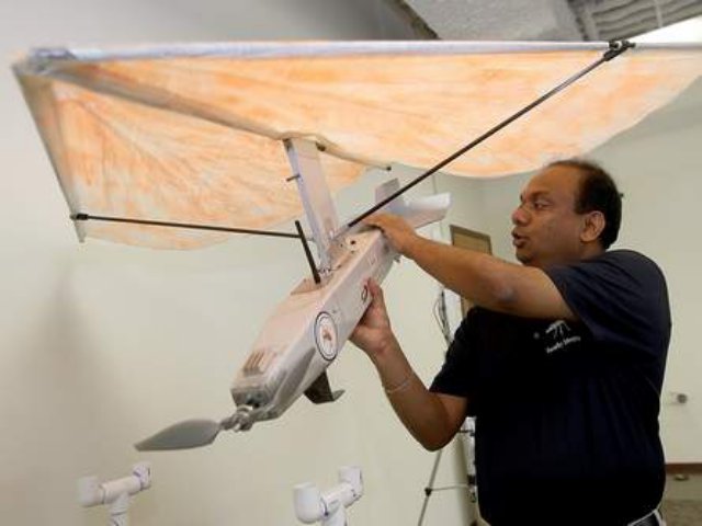
 When it comes to surveying and mapping, a Nicholls State University professor says there is nothing more useful than a remote-controlled plane with a camera and other monitoring equipment strapped to it.
That’s what the university’s Geomatics Department has been using for the past few years, said Professor Balaji Ramachandran, who heads the department. It’s a simple concept that allows students to survey an expansive area far quicker than they have before.
Nicholls has used these battery-powered unmanned aircraft to map the shorelines of barrier islands in the past, and there are future projects in the works. Projects planned to begin in the summer and fall include more barrier island mapping, inspecting offshore oil rigs and monitoring bird habitats, Ramachandran said.
Using a UAS rather than a pilot is safer and cheaper, he said. The unmanned aircraft industry has so many potential uses that pilots are concerned it will soon replace them, though current laws require researchers and police to hire pilots to train them in flying.
Under the Federal Aviation Administration’s rules, commercial industries do not have access to UAS, though they will by 2015, said Charles Easterling, CEO of New Orleans-based Crescent Unmanned Systems. His company has been building unmanned aircraft since 2011 and is working out of the NASA Michoud Assembly Facility.
Ramachandran said he plans to buy a Crescent aircraft built like a helicopter to monitor coastal restoration. Ramachandran said he’s looking for grants and other agencies that could pay for such projects. So far, the university has spent about half a million dollars in state and federal grant money on unmanned aircraft projects.
Ramachandran said he would like the programme to be more expansive, but after “severe budget cuts, I had to bring the whole thing down. … I was more tied up with keeping the (geomatics) programme alive,” he said.
Nicholls is the only agency in the state with a permit to fly unmanned aircraft, FAA records show.
Unmanned aircraft are ideal for coastal areas, Ramachandran said. The university had its drone during the 2010 BP oil spill, but the FAA suspended Nicholls’ ability to use it during that time. Looser regulations in the future may allow a drone to be used to monitor a similar disaster, he said.
“Right after a disaster, this will be an ideal way to get imaging,” he said.
The U.S. Army Corps of Engineers has shown an interest in collaborating with Ramachandran and his research, he said.
“What they’re doing is really great,” Easterling said of Nicholls’ programme. “We consider them to be pioneers and experts in an industry and research field that’s going to be very large in the coming years.”
Source: Houma Today
