
Wildlife management is getting a little more scientific. Saxon Remote Systems, a manufacturer of unmanned aerial systems in McPherson, is flying into the market with technology to make current wildlife management methods easier and more precise.
The only concern? Interrupting wildlife habits with a UAS, or drone, overhead.
“Our aircraft can be pretty obnoxious and loud, so when we fly over the deer, we could spook them because they’re so skittish,” said John Ferguson, CEO of Saxon Remote Systems. “We’ve been working on some projects recently where we’re flying over deer that are worth over a million dollars each. Our clients have asked us to find a solution that’s less obnoxious.”
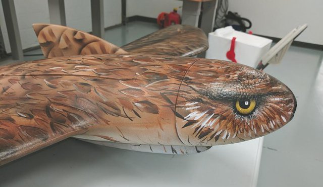
The solution is to blend in. Saxon Remote Systems now can provide clients with customized paint applications that will make their current drone offerings look like a bird.
“This one particular client has an owl in his logo, so he asked that we paint his aircraft like a gladiator owl so we did,” Ferguson said. “It’s opened up a whole new market. Now we can build our aircraft to mimic birds or to look like predatory birds for chasing off pest-type birds like starlings.”
The purpose for this design is not to hide the drone, but to improve wildlife management methods.
“This is not camouflaging a drone. If we wanted to camouflage it, we would paint it gray like the military does, to blend in with the sky. When you do that, you can’t see the aircraft in the air,” Ferguson said.
Game reserves and other wildlife management organizations could benefit from the data drones can provide, without interrupting wildlife behaviours.
″(Systems) can actually identify predatory animals in the environment as well. Our quail population has diminished and part of the reason why is because of coyotes and turkeys eating the eggs,” Ferguson said. “Without disrupting the environment or ecosystem, we can put these drones in the air and possibly get a more accurate understanding of how many predatory animals are in an area.”
Saxon Remote Systems uses methods like radiometric thermal imaging to measure temperatures, live feed video and more at long range, while collecting data in a ground control station.
“If a deer or a cow has a hotter than normal temperature, it might be pregnant or ill or something. Then, we can help spot the animal. If the cow is lost, we can find it in a ravine with thermal imaging and not spook other animals,” Ferguson said. “We can provide the software to count wildlife. It’s very important to know how many animals are in a high-fenced refuge or in a section out in the wild, so it’s important for the fish and game commission to have a general idea of how many types of species are in an area. Using these algorithms gives them a more accurate idea.”
Source: McPherson Sentinel
Great! now a Raptor that has enough to worry about with REAL threats to its domain now have to try and chase these things out of its territory too! People should think about the day to day of a raptor, having to hunt, and feed and defend territory, if it spends all it’s time trying to scare this away, it will be too tired to defend it’s nest from REAL predators.
We generally fly new areas or new mission sets with a Biologist in attendance and only after they sign off on the mission request, this is to help reduce negative wildlife interactions with s/UAS of all shapes and sizes. If a bird of prey tangles with a prop on fixed wing or multi-rotor, , it is not going to go well for either party.