
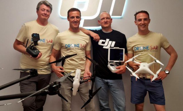
Matthew Kelly and Oisin McGrath from DroneSAR, DJI’s director of Education Romeo Durscher and DroneSAR’s Gearoid O Briain
Ireland’s Donegal-based DroneSAR, has developed unique software that it claims will revolutionise the worldwide search and rescue industry.
“It is an app that transforms basic commercially available drones into advanced search and rescue platforms,” explained Oisin McGrath, CEO of DroneSAR.
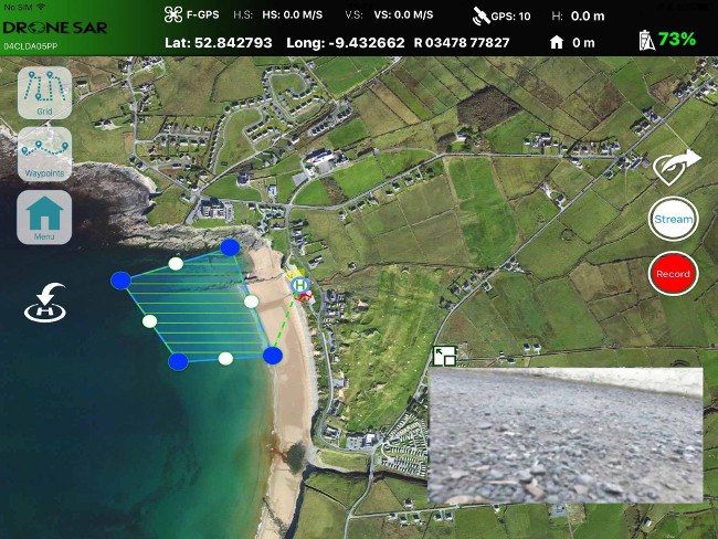
McGrath said the app allows users to choose an automatic aerial search pattern based on variables such as altitude, field of view, battery life and probability of detection.“This results in reduced search time, reduced costs and reduced risk to personnel.”
‘Our aim is to save lives. Our software will reduce risk to search teams and reduce search time. If we can save just one life, that is mission success for us at DroneSAR’
– OISIN MCGRATH
McGrath explained that DroneSAR has the capability to stream live images and video from the drone as it conducts it search to the command and control unit of the agency.
“A number of extra functions are provided where the victim location can be instantaneously shared with the ground search teams. Images of the victim and location, together with GPS co-ordinates are sent via SMS or email as the drones loiters above.
“Completed search patterns are all recorded and logged for easy handover of search areas to oncoming rescue crews. A live stream function allows management to remotely track the drone, patterns it is to fly and view live camera feed from any computer browser.”
The market
According to McGrath, DroneSAR’s target market area includes all denominations of terrain, coastal and inland-waterway based emergency response services for which drone deployment would seek to expedite response speed, situation awareness leading to mission success.
“DroneSAR has already established key partnerships associations with leading organisations in drone manufacturing, crisis management and route planning / tracking software development.
“The first-of-its-kind software was developed based on research done by DJI in conjunction with the European Emergency Number Association and Ireland’s Donegal Mountain Search and Rescue team.
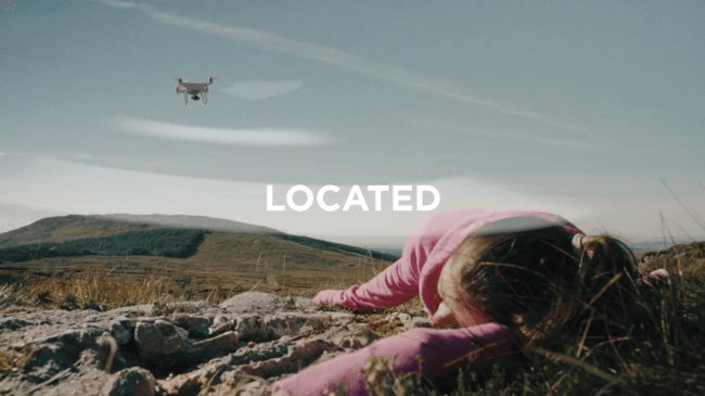
“The groups found that while a five-person rescue team on foot needs an average of two hours to find a victim in one square kilometre, a drone can do the job in 20 minutes or less while taking additional active steps to achieve a successful rescue.”
The founders
DroneSAR was established as a direct result of the collaborative input of four individuals who each possess expertise and skill-sets that are specific to the world of drone technology, network and satellite communication and search and rescue (SAR) coordination and emergency response.
“Each member of the team has contributed proportionally to realise a software product that will play a major part in ensuring that emergency response time-frames, incident coordination, decisions and successful outcomes will be realised across all sectors of the emergency response and humanitarian relief environment,” said McGrath.
McGrath himself is a military helicopter instructor/examiner. He has a degree in Aeronautical Engineering and has a passion for unmanned aircraft technology. He is co-founder of Fly Ryte Drone Academy, Irelands leading unmanned aircraft training centre and a certified military and civilian RPAS instructor and examiner.
Co-founder and CTO Matthew Kelly is an award winning app designer and has developed a number of app solutions that directly integrate with drone technology. He is qualified in Electronics engineering and in Network & Satellite communications. Kelly has been a successful participant of both stages of Enterprise Ireland’s New Frontiers Entrepreneur Development Programme 2015.
Co-founder and director of sales and marketing Gearoid O Briain is a military flight instructor. His background is in fixed wing operations and is a qualified Crew Resource Management instructor. He is also a co-founder of FlyRyte Drone Academy and is a certified military and civilian RPAS instructor and examiner. He has a degree in Business & Aviation Management, a diploma in psychology and is pursuing an MBA at Smurfit Business College.
Co-founder and director of R&D Leo Murray is an R&D Engineer with the Contract Research Unit (CRU) specialising in new product and service development. A member of one of the countries busiest mountain rescue teams (DMRT) for 10 years holding the position of deputy and team lead co-ordinator for the past six years. He led the testing phase of the European based DJI and EENA collaborative project that focused on the application of drone technology for emergency response. Murray has a MSc in Energy Management and a BSc in Project Management.
The technology
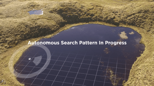
The app takes into account various types of terrain, allowing the drone to fly patterns to survey an area faster and more effectively. Flight paths can be adjusted and various patterns selected for any terrain including hills, mountains, trees or flat land.
The software allows users to choose an automatic customised aerial search pattern which is filled automatically based on variables such as altitude, field of view, battery life and probability of detection.
McGrath said that by organising the process of data collection and providing a framework to manage and analyze it, DroneSAR ensures drones can be used methodically as part of a rescue protocol, allowing personnel to work more safely and effectively.
“From understanding on how to use the technology, to communicating findings and data, to figuring out the most appropriate tactical approach, first responders can benefit greatly from this software app on our DJI hardware,” explained Romeo Durscher, Director of Education at DJI.
“Many of the tasks and strategies deployed during a search and rescue operation can get sped up with automation, helping to reduce the time it takes to find a victim and save lives.”
A rescue platform for the world
“Our ultimate goal is to provide the worldwide rescue market with the most functional rescue specific drone software,” McGrath said.
“With continual research and development, based on feedback from our customers, we aim to provide a robust and efficient solution for global rescue teams.
“Through a collaborative approach, we seek to identify new possibilities and solutions that will utilise space technologies such as navigation, communication, satellite, object detection & segmentation, augmented reality, GIS and sensory systems so that our app solution will successfully deliver when it is needed most.”
Flying high
DroneSAR has been widely received both nationally and internationally since its launch in November 2016.
“Our growth strategy will focus on serving the global market whilst at the same time evolving the apps functionalities to perform in tandem with other key search and rescue (SAR) software solution providers. Exposure to worldwide emergency response agencies affiliated to these partnering companies will help expedite DroneSAR’s presence in the drone software environment.
“Our constant feedback, ideas and development allows our team to prodcue the most specific app for rescue teams based on what they require. Continual product development will allow us maintain our positions as global leaders in this field.”
Turbulent challenges
McGrath outlined some of the common challenges of using drones in aerial searches.
The first big challenge is training, skills and experience. “As these machines are GPS enabled and have auto take-off and auto land functions, the motor skill required to operate them is negligible. They can be removed from the box and flown in 30 minutes. As a result, the machines can give the perception of flying skill which will only become an issue when the flying area or search to be completed gets difficult. Training is paramount, which will include full understanding of the regulatory environment and technical aspects of the machines.”
Another big challenge is field of view. “As we look around day to day, we have an approx field of view of 180-210 degrees. This makes ground search very easy with 360 view by turning ones head. Due to the cameras aboard these machines and the live feed to the operator, the field of view is severely reduced. The normal range is from 78-94 degrees which can cause issues when searching.
“With a visible horizon, determining the drones direction and location is not difficult, but as we search with a camera tilt angle of 60 degrees down, trying to determine the drone location can be difficult.”
And this is where drones come in handy. However, drones will only do what they are told to do.
“As ground based teams become airborne, it is extremely likely that ‘random’ search patterns will be conducted. It is very easy fly the drone in random patterns which will leave some areas eliminated from the area to be covered. A much more regulated search pattern must be used in order that we cover the required area with no areas missing.”
A key aspect is the ability to share location data with rescue teams in real time.
“As we search, we must have a plan as to what will happen once we arrive overhead the victim,” McGrath explained. “Drones are not capable of conducting a rescue but again are very capable to ‘deliver’ a package with some essentials such as a radio, a hypothermic blanket, etc. Another consideration is that we have to be able to share the drone location once the victim is found. The team members must be able to receive the location of the victim, as quicky as possible, in order to concentrate resources on the rescue. Off the shelf drones do not have this capability without adding specialist software.”
The start-up scene in Ireland soars
McGrath said that the start-up scene in Ireland is both exhilarating and challenging.
“The start-up scene is one of the mosy exciting times I have had in my life. The constant drive, need for success coupled with the recurring challenges has pushed our team to places we had never thought possible.
“It is a huge learning curve, but we have quickly come to terms with where we want to be and everyone is not afraid to put in the hard work on a consistent basis. We have had opportunities to speak at conferences, events and drone shows throughout the world that we attended for research purposes only two years ago. It has been an incredible journey so far and we all look forward to our continued international success.”
However, the key is to avoid hubris and focus on priorities.
“We entered the start-up world at a difficult time financially. Our advice would be to carefully select your team based on the skills they can bring to the company.
“Having a the skills internally to allow you to expand with very little financial input at an early stage is absolutely necessary. Out-sourcing early development tasks is unecessary and will not allow you to concentrate your limited finances on marketing.
“Take risks. Unfortunately, risks are a necessary part of any start-up. Try and avoid financial risks but risk your spare time.
“Read as much as you can. Use your spare time, however limited, to develop new skills, meet partners and for self development. Remember, that if your company fails you will always have these new skills and self-gained knowledge.
“Every now and again, stop … take a step back … and observe what you have achieved and take pleasure in it. Take it all in and enjoy the experience!”
Images: DroneSAR
Source: Silicon Republic
I recently purchased a Mavic Pro drone, and I am also in the US Civil Air Patrol which has search and rescue missions. I am part of the aircrew (Mission Pilot and Mission Observer), and I see a tremendous value using this software with my drone. The aircrew could be used to get the general area of a missing person/aircraft and the drone using your software could be used to work closely with our ground teams to fine tune the final phases of the search. This would be more precise and reduce the costs/time of aircrews.
Please send me more informaition.
Marv,
I suggest that you click on the link in the article to the DroneSAR website and contact the company…