
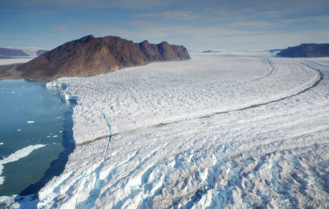
Walking near the end of a massive tongue of glacial ice rising hundreds of meters above the sea, a group of scientists spotted an unexpected and ominous sign. About 100 meters from the edge of the glacier was a crack a few meters wide. The crack was fresh—there was no sign of it the day before. “We decided we wouldn’t walk farther,” said Guillaume Jouvet, a glaciologist at ETH Zurich in Switzerland.
He and his colleagues were on a 2015 expedition to Bowdoin Glacier in northwestern Greenland for the express purpose of deepening scientists’ understanding of when, how, and why such fissures form. But the fissures were just a means to an end; the team was out to piece together the series of events from the start of a crack to the moment when an iceberg breaks free at the glacial front.
The international team of researchers including Jouvet, led by glaciologist Martin Funk, also of ETH Zurich, recently reported in The Cryosphere that they used images collected by an unmanned aerial vehicle (UAV) to model how ice fractures propagated in this glacier. The crack resulted in a 1-kilometer-long iceberg breaking away from the front of the glacier, which is about half the area of Manhattan Island. Combining observations of visible ice fractures with modeling of a glacier’s interior, as the team has done, is a powerful technique for better understanding, and potentially predicting, when and where glaciers will produce icebergs, the researchers suggest.
This work “yields insights into the production of icebergs, which are increasingly affecting human societies,” said Mark Carey, a glacier researcher at the University of Oregon in Eugene not involved in the study. The current number of icebergs drifting into North Atlantic shipping lanes is “among the highest in a century,” he added.
A video that the researchers made of this revealing fieldwork includes footage taken by the UAV’s camera.
Flying Eye
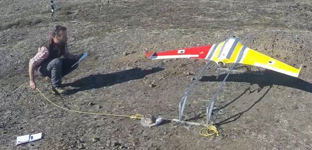
The team’s 2015 observations of the glacier built on previous studies of the flowing ice there by some of the same researchers using automatic cameras, GPS measurements, and ice-penetrating radar. This time, however, the scientists brought with them a piece of technology that’s increasingly popular in geophysics research: a UAV.
Team members mounted a camera on the battery-powered craft. Then, on 11 July, after overcoming reliability issues with the UAV’s compass related to the nearby North Pole, they guided the craft over the terminus of Bowdoin Glacier.
The camera snapped roughly 1000 overlapping photographs during the 30-minute flight. The researchers then used computer software to construct a three-dimensional model of the glacier from the data. The resulting image was “like a satellite view, but very high resolution,” said Jouvet.
The next day, the team explored the glacial front, where they noticed the crack near the glacier’s edge. But when they later scanned the previous day’s UAV images, they saw no sign of the crack.
Five days later, the team launched the UAV again and assembled another three-dimensional image of Bowdoin Glacier. This time, the researchers found the crack easily: It had grown to 750 meters long. By comparing the two high-resolution UAV data sets using a feature-tracking algorithm, Jouvet and his colleagues traced how the ice moved and calculated its velocity at 1-meter intervals. But the UAV images revealed only the glacier’s surface—the real mystery lay within. “We wanted to somehow enter the glacier,” said Jouvet. For that, the researchers turned to modelling.
Hundreds of Artificial Glaciers
Members of the research team, which included scientists from ETH Zurich and Hokkaido University in Sapporo, Japan, simulated more than 100 versions of the terminus of Bowdoin Glacier on a computer, each characterized by different internal properties such as bedrock topography, friction between bedrock and ice, and ice stiffness. They also modelled whether, at the time of the 16 July second flight, the crack might have been partially filled with water, a condition that would have widened it more than had it been empty.
By comparing the properties of these artificial glaciers with the actual surface features of Bowdoin Glacier, the team found a best fit model indicating that the crack was water filled and 175 meters deep, roughly two thirds of the total thickness of the glacier. “The fracturing process was quite advanced” by then, said Jouvet.
He and his colleagues didn’t attempt to predict exactly when Bowdoin Glacier’s massive iceberg would detach. That happened on 27 July, about a week after the researchers had packed up and left Greenland. A roughly 1-kilometer-long section of the glacier calved off as an iceberg, which then broke apart in the water. “Fishermen saw a lot of icebergs coming from Bowdoin Fjord” that day, Jouvet noted.
He added that the team’s technique of modelling ice fractures could “absolutely” be applied in more places than just Greenland. For instance, the method could be used to infer the properties of the enormous crack that’s currently developing in Antarctica’s much larger Larsen C ice shelf, which spans hundreds of square kilometers. However, he said, monitoring such a large area might be better accomplished with satellite images than UAV images.
Now Jouvet is leading a project to actually predict the formation of cracks responsible for massive icebergs. He plans to return to northwestern Greenland this summer to use a fleet of UAVs to collect the project’s first data. He said he hopes to record a large event, from the initiation of the first crack in the ice to the final launch of the iceberg.
Top Photo: A large crack splits the ice about 100 meters from the face of Bowdoin Glacier. Credit: Julien Seguinot, ETH Zurich
Centre Photo: A member of the research team launches a camera-equipped unmanned aerial vehicle to fly over the terminus of Bowdoin Glacier and snap photos of the glacier’s surface. Credit: ETH Zurich
Source: EOS
Looks like an Optera. Great Platform with lots of room inside for either payload or batteries. Fascinating to see their work.
To me this seems to look like a Skaywalker X8, not Opterra, anyway, great platform, nice work guys!