
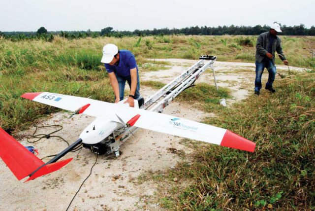
After the technician’s countdown, “moi, pi, bai”, an AS-III fixed-wing drone launches off a catapult into the air, ascending rapidly at 25 metres per second until it is high above the Cambodian countryside. The drone, equipped with a special camera capable of detecting what the human eye cannot see, surveys the crops below, assessing the health of vegetation while charting the precise layout of the terrain.
Operated by the local firm SM Waypoint, the drone can soar at an altitude of 3,000 metres and has a range of 180 kilometres, during which it takes photographs to find areas of low crop yield or make accurate measurements of topography. However, despite Cambodia’s large agricultural sector, few farmers are even aware of the technology, let alone using it, according to Jimmy Jacks, the company’s managing director.
Established in September 2015, SM Waypoint now has seven drone pilots, two sales staff and two accountants, with Jacks the only foreigner on the team. He explained that the technical operations of the company are handled by the local employees, who underwent specialised training in the country and have degrees in engineering, geology or mining.
The company operates two fixed-wing drones, the larger AS-III, with a 3.3-metre wingspan and capable of covering 1,800 hectares in one flight, and the smaller and more manoeuvrable eBee Ag drone, with a range of 5 kilometres and 30-minute flight time capacity. Both can take precise ground measurements through modified digital cameras programmed to snap photos every 2.4 seconds.
Jacks, a former aviation pilot, said the drones’ technology is similar to what he used in commercial planes. He added that the autonomous drones, which follow a pre-programmed flight plan, are capable of extreme precision, producing images with a resolution up to 3.8 centimetres from high in the air.
“You can look at a bug on leaf,” he said.
Though the company focuses mainly on agricultural projects, the potential uses of the drones are extremely varied, going from measuring exact land height for building drainage systems to finding the most suitable location for special economic zones (SEZs) or factories, according to Koeurn Chenda, SM Waypoint’s unmanned aerial vehicle (UAV) team leader.
He explained that the data collected by the drones are processed at the company’s headquarters to create various digital models, such as 3D images that can be used to analyse land and crops. Even on a dedicated server with 128 gigabytes of RAM, it can still take up to 10 days to process the vast volume of data retrieved from a single flight.
SM Waypoint’s most popular product is measuring the Normalised Difference Vegetation Index (NDVI) of crops, which provides an evaluation of the relative state of health of a farmer’s plants.
“When our drones fly around, they use a special sensor that captures the amount of near-infrared light and red light emitted by the plants,” Chenda explained. “When there is healthy vegetation, it will emit higher near-infrared and low amounts of red light.”
By presenting the farmer with an NDVI survey of his entire plantation, he can quickly spot areas where plants are stressed and take early corrective action.
While SM Waypoint recognises that drones are not affordable for all, especially smallholder farmers, Jacks said the technology makes economic sense for large-scale farms and plantations.
“We don’t even have to argue that using drones properly and following up would increase your yields by 10 percent,” he said.
Offering an example, Jacks said the increased yield on a rice farm producing 900 kilograms per hectare would be an additional 90 kilograms per hectare. At current rice prices, this additional yield could be sold for about $20 per hectare, while the price of flying the drone would cost about $4.5 per hectare.
Moreover, the technology is highly useful in identifying and correcting one of the most vexing problems of rice agriculture in Cambodia – uneven topography.
“It is critical in rice farming to have level paddies,” Jacks said. “If your paddies aren’t level, one area of rice will have too much water on it and the other one will be starved.”
While he admitted local farm and plantation owners have been slow to adopt drone technology for their crops, in other countries the aerial devices are used extensively.
According to a report released by PricewaterhouseCoopers in May 2016, the total addressable global market for drone solutions was valued at over $127 billion. Infrastructure and agriculture were cited as the areas with the best prospects, valued at $45.2 billion and $32.4 billion, respectively.
“In order to keep up with increasing demand, agriculture will have to revolutionise the way it produces food and become much more productive,” it said. “Drones will allow farming to become a highly data driven industry, which eventually will lead to an increase in productivity and yields.”
The report, titled Clarity from above, said the cost and versatility of drones was helping to replace more expensive forms of monitoring, such as satellites and manned aircraft. It added that globally, the lack of a clear legal framework for drone usage was one of the main barriers for more widespread adoption of the technology.
“The regulatory aspect of commercial drone operations is currently one of the most important factors affecting the pace of drone powered solutions’ adoption by businesses and government entities,” it said.
Chan Sophal, director of the Centre for Policy Studies (CPS), said he believed Cambodia’s major industries could greatly benefit from the use of drone technology, particularly when it comes to prospecting or monitoring landscape.
“For economic land concessions, where ground accessibility is still almost impossible, especially in the degraded forest areas, drones would be invaluable in verifying the status of concessions,” he said.
“I believe Cambodia should embark on this technology as soon as possible for the purpose of agriculture, whose statistics based on administrative reporting are still not very reliable.”
Source: Phnom Penh Post
I went to Cambodia last year and trained the SM Waypoint team to use another fixed wing system, the C-Astral Bramor. It was an absolute pleasure to be involved with training up their team and they were extremely professional and receptive. I am sure that they will be delivering a great service to their customers in Cambodia. Well done.
Thanks Mike! You were a real professional.
Jimmy