
 DroneDeploy, a cloud software platform for commercial drones, is making powerful aerial data accessible and productive for everyone with the new release of its fully integrated, free iOS and Android app, to deliver a more seamless and engaging drone mapping experience.
Now anyone with the latest drones from DJI, the world’s leading drone maker, can not only autonomously fly and capture images, but can also analyze their drone imagery directly from within the DroneDeploy app.
“Automating drone flight and image capture is critical, but only half the story,” said Mike Winn, CEO and cofounder, DroneDeploy. “The real value is in deriving insights from the data. By creating an integrated app which includes both drone flight and data analysis we’re helping our users better extract insights while in the field, giving them a competitive advantage.”
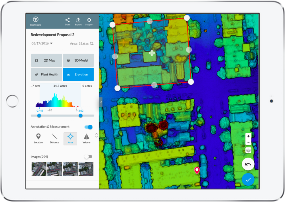
The new integrated drone mapping experience enables faster and smoother transitions between drone flight and data analysis. The DroneDeploy design team focused on key mobile elements, such as intuitive interactive touch, contrasting colors for better outside viewability, and bringing annotations and other key functionality to the forefront. Beta testers found the app, which is mobile optimized for analyzing drone maps and 3D models, extremely engaging. ‘Time spent’ with the Map Viewer increased by two and half times as compared to the previous desktop version.
The new DroneDeploy iOS and Android app is a big step forward for the commercial drone industry. It includes enhanced flight planning features, such as the ability to rotate the flight direction and easily select the starting waypoint when continuing previous missions. It also includes an entirely new central dashboard designed to help users quickly sort through their aerial maps.
DroneDeploy users, from hobbyists to leading global enterprises, have produced and analyzed millions of acres of maps in more than 100 countries. DroneDeploy is transforming industries. Farmers are identifying irrigation and pest issues, and creating better prescriptions. Construction sites and mining operations are increasing their efficiency, reducing costs and increasing worker safety. Insurance companies are inspecting multimillion dollar claims.
The DroneDeploy iOS and Android app, which include live stream First Person View (FPV) support DJI’s best drones for automated flight, including the Phantom 3 Pro, Phantom 3 Advanced, Inspire 1 and Inspire 1 Pro, and Matrice 100. Operators of nonDJI drones can use Embargo until 7am PDT, May 25, 2016 the DroneDeploy Map Engine to process geotagged images from any drone manufacturer and leverage the redesigned app to view their drone maps and 3D models in the field.
On the heels of DroneDeploy’s recent release of shapefile exports and its new agriculture offering, and with today’s release of the fully integrated iOS and Android app, DroneDeploy continues to show its leadership and innovation within the commercial drone industry.
Source: Press Release
This is a great news! Drone Deploy on iOS and Android platform will provide seamless drone mapping experiences. Quite an interesting app.