
One of the biggest stumbling blocks to widespread unmanned aerial systems operation is situational awareness, especially in the United States, which has the busiest airspace in the world. One company, however, argues that providing situational awareness is just a big data and analytics challenge.
Simulyze, an operational intelligence and technology application company, can trace its roots in UAS operations to its work with the military post-9/11. It’s now expanding its software, which has been used by the military for the last 16 years, to target the UAS marketplace because “it has a very similar problem set,” Simulyze CEO and President Kevin Gallagher told GCN.
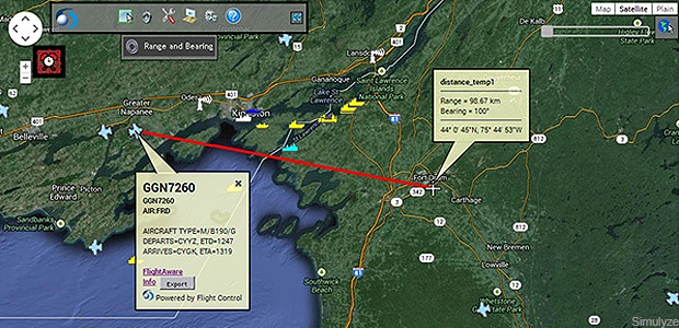
The Mission Insight software now being applied to the commercial UAS sector fuses various data streams together as a means of providing a common operating picture for operational intelligence and situational awareness. “We process all the data about the platform, what the sensor is, where it’s looking, how fast it’s going, where it’s at,” Gallagher said.
The system also integrates weather information and data from ground-based GPS systems showing the location or velocity of other aircraft in the area. This information can be processed in real time to support planning, real time operations and post-mission analysis. “We’re an enabling technology for traffic management” for planning and day to day operations, he said.
Currently, Simulyze is partnering with NASA’s UAS traffic monitoring system, and the Federal Aviation Administration is deploying Mission Insight at various test sites.
The application could support organizations with a fleet of devices they might need to coordinate through an operations center all the way down to the individual operator who needs good situational awareness to monitor the flight, weather or obstacles for a specific UAS.
Mission Insight’s data is delivered via a graphical interface displaying the information collected. “We’ll put all that data into a single display like Google Earth, and you can click on the objects and … pull up extra information,” Gallagher explained. Selecting the UAV icon will display information on the drone’s latitude, power and remaining battery, for example. A click on other aircraft in the area will show what kind of aircraft it is or its flight plan, he said.
While there are several datasets to pull from in the civilian environment, Gallagher said there is a push to require still more data and information sharing. After all, situational awareness is only as good as the data sets available.
Source: GCN