
 Flying drones in Antarctica is not easy. A 100-110 degree difference between true and magnetic north at this location complicates navigation. There’s zero terrain protection against the strong headwinds that cut through like a knife, there’s snow, and drone batteries discharge quickly in the freezing conditions.
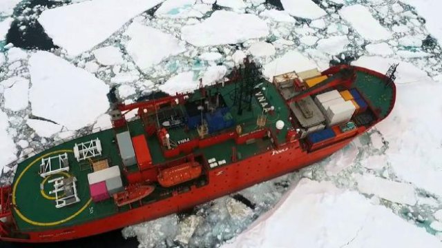
But after the successful use of drones to guide the Aurora Australis icebreaker through treacherous waters on its annual resupply voyage to Casey Station in December, it seems the sky’s the limit for this kind of technology on the southern polar continent.
Australian Antarctic Division future concepts manager Matt Filipowski says this is the first time the division has used drone technology to assist ship operations, and it is a valuable addition to existing ice navigation tools, which include satellite imagery and radar.
A hovering quadcopter made five flights of eight minutes each during the nine-day voyage to Casey. Then a fixed-wing drone was used to map the area around the station from the air, mapping 30ha in 20 minutes.
The division will now assess the project and decide what’s next. But it seems drones are set for a significant role in ship navigation there. The AAD previously has used drones for vegetation mapping and other countries have flown them from ice breakers. Australian researchers have used drones aboard US icebreaker Nathaniel B. Palmer, but this one-month experiment starting in early December last year aboard Aurora Australis was an all-Aussie affair.
Drones or unmanned aerial vehicles, as the industry calls them, are cheaper to operate, quieter and less disruptive than helicopters, and can take high-definition images close to the ground, as evidenced in the beautiful aerial images of Casey Station and the Aurora Australis negotiating ice.
The hovering multi-rotor and sweeping fixed-wing UAVs were piloted by James Rennie, an environmental scientist for 17 years and director of Australian UAV, which in October last year won a tender for the trial. Rennie flew radio-controlled aircraft for 10 years before obtaining a private pilot’s licence and being an accredited UAV pilot under Australian regulations at the time.
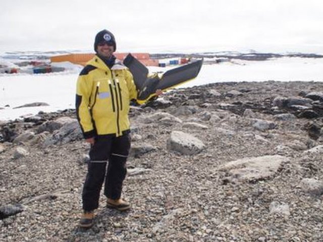
Environmental scientist and drone pilot James Rennie at Casey Station. Picture: Australian Antarctic Division.
Ground Effect Aviation was the first Australian UAV training organisation to be accredited by Australia’s Civil Aviation Safety Authority, and Rennie was its first graduate. The company Rennie launched three years ago operates eight multi-rotor and seven fixed-wing drones with pilots in Melbourne, Ballarat, Sydney, Brisbane and northern Tasmania.
Rennie now sees a world of new possibilities for drones in Antarctica, including counting wildlife, mapping geological features such as glaciers and crevasses, and even creating full 3-D models of Antarctica terrain. It will also be easier to study habitats and migration patterns.
Even in Australia, operating UAVs to 400 feet (122m) has its dangers. Wedge-tailed eagles, seemingly the sharks of the upper skies, can spot one of Rennie’s drones from up to 20km away and within minutes swoop and send it crashing to the ground.
“We have a wedge-tailed eagle attack every single day without fail,” says Rennie, who reveals that the eagles have taken out every one of his $40,000 to $60,000 fixed-wing drones at one time or another. “They have an awful hatred of anything else in the sky.”
On the Antarctic voyage, the problems were different. He couldn’t calibrate the drones’ compass on Aurora Australis, a large metal ship. That was necessary given the growing difference between true and magnetic north as the ship headed south.
The AAD explains on its website that as a compass gets closer to the South Pole, the south-seeking end of the needle is pulled downwards towards the earth and will drag on its enclosure unless a counterweight is added to the north-seeking end.
“There’s no way of calibrating a compass on a ship — there’s too much magnetic interference,” Rennie says. “You’re effectively standing on a giant magnet and you can’t isolate yourself from it.”
So he ruled out using a compass with drones entirely. And without a compass operating, his drones couldn’t use GPS — although 19 satellites were available to aid navigation. “It then becomes a completely manual flying operation, which has its challenges,” Rennie says.
Hobbyists are banned from flying drones in Antarctica or from cruise boats in the Arctic region, mainly because of the possible environmental impact, but also because owners are unaware of these enormous issues working in polar regions. Their drones invariably end up in the sea.
Take batteries: Rennie had to insulate the lithium polymer batteries in lightweight EPP (expanded polypropylene) to keep them warm in subzero conditions, otherwise they would have discharged. There were winds of about 17 knots and, with the constant low-pressure systems, manual flying was a challenge.
“My biggest concern was the magnetic interference of the ship would shut down the multi-rotor UAV completely and it would refuse to start,” Rennie says. “We conducted tests to make sure it would take off and wouldn’t be interfered with by the communication systems of the ship.”
During the month-long venture, Rennie began with hover flights below catch-netting on the ship that was designed to prevent the drone veering off. Then the drone was flown away from the vessel at altitude; later he trialled piloting in high wind and driving snow. “We really tested it in the extremes.”
Mapping Casey with a fixed-wing UAV seemed a relative walk in the park. “With aerial surveys we can cover 600ha a day with a 5cm vertical accuracy,” Rennie says.
In Australia, his drones are used to avoid “the dull, dangerous and dirty” of land operations. The company monitors about 12 landfill sites a month — it takes a UAV only 15 minutes a site instead of hours by a person on the ground.
It also conducts end-of-the-month stockpile analysis for mines, and monitors quarries and even a goldmine in central Victoria. And its UAVs count trees in plantations.
“We’ve counted about 2.5 million trees in the last few months,” Rennie says.
“Rather than send a couple of people out to count trees and have them walking around areas with snakes and slips and falls, we can fly over a while plantation very quickly and with an algorithm we have developed we can automate counting all the trees.”
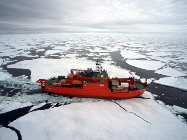
Aurora Australis in ice. Photo:Australian Antarctic Division
Australian UAV now has more than 100 clients. “We assess pipeline routes, we assess rivers, we look for feral pigs and feral goats, inspect mobile phone towers and water towers,” Rennie says. “The last few weeks have been almost exclusively beach surveys. We look at coastal recession, sea-level rise, beach erosion, and aerial surveys for design works. No two days are the same.”
Australian UAV plans to expand from five pilots to 15 to 20 staff by the end of next year.
The company is one of more than 400 registered UAV-related businesses. Companies have cottoned on quickly to the potential of drones commercially, and business is set to boom.
Last year The Australian reported on Ninox Robotics, a Sydney-based start-up whose UAVs were the first commercial drones to conduct test flights at night. Using infra-red technology, they scoured Australia’s bush at night for feral animals. The drones could be flown remotely or programmed to fly themselves.
Ninox managing director Marcus Ehrlich said the company was in discussions to employ former military drone pilots who had flown operations in Afghanistan.
Source: The Australian