
 A group of scientists is taking the problem of plastic pollution in the oceans by land, sea and air. While Marco Simeoni, the president of the Race for Water Foundation and his team spend 300 days in a yacht collecting samples of all the plastic pollution found in the ocean, a drone is flying over uninhabited beaches collecting images of converging garbage on its shores.
“This kind of pollution is probably one of our biggest environmental challenges,” explained Simeoni of the project. “We’re talking about water, about fish and birds, about some of the most precious resources we have – and the long-term damage we inflict upon them. There’s an urgent need to act – it’s a race against time.”
The team is then wasting no time with its multi-pronged approach. The swiss team aboard the yacht started their research that will eventually visit all five major garbage vortexes located in three different oceans a month ago. The Swiss scientists stop in these places where plastic pollution accumulates and get samples of it that are then sent for analysis at the Swiss Federal Institute of Technology (EPFL) in Lausanne.
Concurrently, a crew flies drones that are mapping where other big trash accumulations are in the world.
“There are special lenses that you can put on the drone’s camera, and you will get images that will show the plastics very well, separate from the background,” said Ari Friedlaender of the Marine Mammal Institute of Oregon State University. “Any data we can get from there will be informative. The first thing to do will be to count and quantify the debris. We will be able to tell what it is, and how much there is. And this information, in turn, might give us some indication of where it’s coming from. And then, once you know what you’ve got to deal with, you can come up with ways to mitigate and remove it and start cleaning up.”
Friendlaender and David Johnston, from the Practice of Marine Conservation and Ecology at Duke University, are two American scientists involved with the project that is making all the data collected from the drones available online to the public.
As they explained, the crew can “literally throw the drone up into the air and it goes on to collect all the data as programmed and then returns. The crew will fly as many missions in a given location as we tell them. When they call into the next port they will download the data onto a hard drive, which is sent to us. Once we begin our analysis it won’t take long to get results and we can start mapping the data. So far, the programme hasn’t experienced any glitches.”
“A lot of the science we’re otherwise involved with is more about basic knowledge. This project is much more practically oriented: not only should we be able to see how much plastic waste floats in the oceans but hopefully the collected data will allow us to take the next step toward solving the problem. For us it’s an opportunity to make our science matter in a very important way,” said Friendlaender.
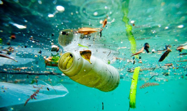
Every year, 250 million tons of plastic are produced and it is estimated that ten percent of that ends up in the ocean. The pollution occurs by land (from industrial, agricultural and domestic activity) or by sea (from maritime traffic, fishing, aquaculture and oil platforms). Either way, the plastic affects ecosystems, traps wildlife, and poisons both the animals living in the ocean and eventually humans that eat them.
Source: ecorazzi