
 SkyIMD is a one-stop source for deploying an aerial surveillance system which usually involves multiple technologies and providers. The company is now promoting a new service using manned UAVs equipped with gyro stabilized gimbals and geomatic cameras pre-programmed to automatically follow GIS (Geographic Information System). The camera systems can be live controlled and viewed from the ground over an unlicensed microwave link. A 6 hour/500 mile duration is more than most drones, yet operational costs are less, and there are no flight restrictions (day/night, IFR/VFR, urban areas, altitudes).
Cessnas flown solo as manned UAVs are inherently less expensive than unmanned aerial vehicles (UAV), and are legal in all airspace. Equipped with the same unmanned aerial systems (UAS) sensors, the manned UAVs on large commercial missions will:
- Operate at a lower cost per mile, or per acre
- Have longer flight duration and better stability
- Provide faster and greater coverage beyond line-of-sight
- Use the same or less personnel resources, and are easier to use
- Offer more payload weight, electrical power, and sophisticated instruments
SkyIMD can provide up to three imaging pods per single engine Cessna. Manned UAV payloads include SkyFusion Pak camera system with EO/IR (Electro Optical/Infrared) superzoom, precision agriculture multi-spectral sensors, and extreme resolution photogrammetry geomatics cameras. They are FAA approved, and can be flown now unaffected by the new unmanned regulations.
Manned UAVs have two configurations:
1) Automated: Sensors automatically follow imported GIS (Geographic Information Systems) data, record imagery, and transmit video. The pre-programmed autopilot leaves the solo pilot to focus on traffic between takeoff and landing.
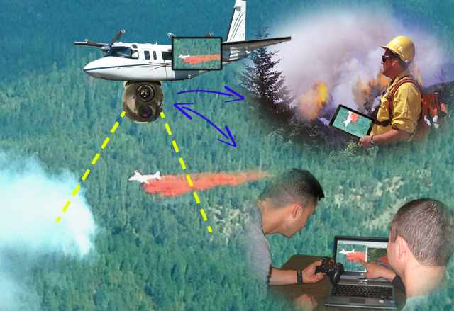
2) Ground operated: System video, command, and control is microwave-linked to the ground without noticeable delay. Over the internet, operators anywhere in the world can engage hands-off automatic tracking by clicking moving objects, visual scenes, or GIS (pipelines, shorelines, search grids, etc.). New pre-programmed course GIS can be uploaded real-time, and manual slewing camera controls work seamlessly together.
Both configurations duplicate all functions for interactive use in the cockpit, allowing airborne operation the old-fashioned way. This is a reliable safe backup to completing missions if UAV ground connectivity is lost. A split screen moving-map with video overlaid augmented reality is always visible. Preloaded background street maps provide instant situational awareness with topography (topos), aerial photos, imported GIS, and 3D visualization.
Mark Zaller, Chief Operating Officer of SkyIMD, says, “Cessnas are less expensive and easier to operate than most drones, and many times more effective. For more than two years, a Law Enforcement agency has flown a Skyhawk solo on scheduled patrols using SkyFusion Pak’s day and night sensors. Pilots receive only the mission coordinates for privacy reasons while deputies, at their office desks, provide fast incident response and birds-eye assistance to ground officers.”
Cessna factory installs SkyIMD’s SkyFusion Pak on 172 Skyhawks, 182 Skylanes, and 206 Stationaires. The new diesel Cessna 172JT-A and 182JT-A will provide even longer flight duration and lower operating costs. Existing aircraft can be installed with an FAA approved Supplemental Type Certificate (STC) directly from SkyIMD. Aircraft retain all types of commercial flight operations with or without the sensor pod present (pilot removable/installable in under 10 minutes).
Kirk Demuth, CEO of RoboFlight, says, “RoboFlight, a Precision Ag company, started with only UAVs, and now SkyIMD systems allow us to fly regular Cessnas over larger acreage for less cost. These readily available aircraft and systems will increase farmer efficiency, reduce environmental impacts from excess nutrient and chemical runoff, keep food costs to a minimum, and increase food supplies worldwide.”
Source: Press Release
About SkyIMD, Inc.
SkyIMD creates aerial imaging, mapping, and data communications solutions for commercial and government customers worldwide. The company integrates best of breed technologies into cost-effective, full-featured solutions for light airplanes, helicopters, and UAS. From installation to operation, it is plug-and-play easy for untrained workers to conduct sophisticated missions previously requiring elite training.
The SkyFusion Pak is a turnkey, lightweight, gyro stabilized, multi-sensor system that mounts on the wing strut or belly of single engine Cessna aircraft. It features high-zoom capability from any altitude, and the ability to send Google Earth photos and live streaming video to iPhones and Androids of ground personnel. FLIR infrared sensors are used to see at night and through smoky conditions. Low cost, quick to install FAA STCs are available for 64 different aircraft models.
A manned unmanned aerial vehicle ? I believe you need education. Your sentence structure is unbelievable believable.
A manned unmanned aerial vehicle? It’s not a UAV if it’s manned, so why not just call it what it is; a piloted aircraft.
Manned UAV is oxymoronic.