
 Luys scholar at MIT Armen Mkrtchyan is dreaming big about the sustainability of rural communities in Armenia. With a background in aeronautics and astronautics, Armen is working on the unheard-of — a UAS that can analyze the quality of soil for Armenian farmers using imagery.
The problem farmers have faced for decades has been properly caring for the health and viability of their land.
“Farmers tend to treat their farm as a homogenous piece of land, which it’s not,” Armen explains. “They apply the same amount of fertilizer and pesticide to the whole field, although different parts of the field don’t grow crops the same way so they don’t need the same amount of treatment. This often results in a lot of wasted fertilizer and pesticide for some areas.”
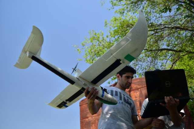
Armen has developed a small unmanned aircraft system (UAS) that flies by itself, like a drone. He actually calls it an “agrodrone,” which is hand launched and flies over crop fields, taking pictures. The software Armen has written can analyze the images and provide a vegetation health map that shows the health of areas of land.
With these images, farmers can instantly determine the acceptable growth rate. Although the idea of taking images to compute the healthiness of crops has been around for many years with the use of satellites, they work on a much larger scale. But Armen’s UAS can take pictures of a farm with much better accuracy even for small farms. Farmers can then determine how much fertilizer and pesticide to apply to which areas, thereby optimizing spending and increasing yields.
Armen says that according to market research conducted mainly in the US, this will decrease spending by about 30 percent on chemicals and will likely improve yield by 10-20 percent.
“This can result in significant savings, considering low (and seasonal) monthly income of Armenian farmers,” Armen said.
Armen grew up on a farm operated by his grandparents near Mrgashat, located in the region of Armavir, only a five-minute drive from the city of the same name. Their land supported an apricot orchard — where he’s conducted testing of the drone this past summer — a vineyard spanning 1.2 acres and cherry and other fruit trees.
”I used to work on the farm, apply fertilizer and pesticide,” he recalls. “I used to take the cattle out when I was young, they used to wake me up at 6:00 am. And I hated it, but I think its part of the process of growing up and knowing what work is.”
Armen spent two years acquiring fundamental skills in Mathematics, Engineering, and Physics at the Department of Radio-Physics at Yerevan State University (YSU) before moving on to the University of North Dakota at Grand Forks in 2006 to pursue an undergraduate degree in Electrical Engineering. There he was at the Unmanned Aircraft Systems Engineering Lab, where a few people were working on the agrodrone idea but on a larger scale. The planes were bigger and had a 10 ft. wingspan weighing 50-60 pounds and used expensive cameras to track vegetation health.
“Then I thought, what if I can do this in a developing country much cheaper?” he said. “What if a farmer doesn’t have $10,000, but maybe he can afford to pay you $20-30 per month to get this data. And that’s where the idea came — trying to create something that’s much smaller and cheaper.”
He went on to obtain a Master’s Degree from the Department of Aeronautics and Astronautics at MIT, where his research dealt with modeling human interaction with UAVs. He is currently pursuing a PhD at the same department, which he plans on defending in 2015.
Armen’s plane has a 4 ft. wingspan compared to 10 ft. and only weighs a few pounds. It would cost only a fraction of what other competing products cost, mainly due to the custom-made camera system and various other circuitry that was designed for affordability.
Love for Luys
Armen was one of the first Luys scholars from 2009, the year that he started at MIT. For him, Luys Foundation is about so much more than the funding it provides to students located throughout the Armenian World.
“Luys provides a connection to the people,” Armen explained. “It provides a community with a forum to share your ideas and not be afraid of saying something that would be considered futuristic like my project, which it’s not. It’s technology at work. But Luys is about helping with resources, which I think is what its best at–connecting people. The attitude is ‘let’s see how far you can go, but also how far by collaborating with others who are willing to help.’
“The Luys scholarship has given me the freedom to choose a research project that I am personally passionate about. More importantly, through Luys I have gained access to an incredible network of people who are enthusiastic about helping each other achieve their dreams. It is this network of young students, mentors and professionals that will stay strong and continue to develop for a long time.”
Future Plans
One of Armen’s dreams is to start a research center in Armenia that would not only benefit him but also Armenian citizens.
He is developing a framework for companies, small or large, who want to create products for developing or emerging countries.
“There’s been a lot of studies conducted in the past that show that products that are made for developed markets don’t really work well in developing markets,” he said. “The needs aren’t the same, people can’t afford them, and conditions are different–for a whole bunch of reasons. So I’m trying to develop this framework that we can provide to startups or financial companies to develop products.”
Most of his research is actually being conducted in Armenia. He has spoken to several IT companies in Armenia to discover how products can be developed for the Armenian market, even though most are outsourcing to foreign markets. His intent is not only to produce his UAS in Armenia but also export the product to other countries.
“If we can develop the UAS in Armenia, we can export it to the US for example, and to Australia, Eastern Europe, Russia, where the market is much larger than the Armenian market,” he said.
“The plan is to have enough money raised to start the actual commercial phase rather than the developmental phase when I’m done with my studies and not postpone until it’s too late. It’s going to be a very crowded space as UAS are becoming very popular, so I cannot afford to wait.”
Source: hetq
Congratulations go out to Armen. First for focusing on agriculture UAS/UAV and also the fact that farmers needs are different than other uses. His company and http://www.AgEagle.com understand what farmers and agronomists need or want. They are not enamored with Drone/UAV/UAS technology but rather what will the results of the technology do for me to increase yields, reduce input costs or both. One area that Armen may need to overcome is the fact that in many parts of the world like, the midwestern part of the USA, during the spring when aerial imaging can provide the most help is also when the wind is blowing the hardest. Most hobby type airplanes are not capable of flying in high or gusty winds. The AgEagle has flown successful agronomy aerial imaging in winds blowing at 34 mph. Many airframes that fly well in high winds are also difficult to hand toss. For this reason a catapult launcher makes it safer and simpler for agronomists and farmers.
The other element that is important to farmers and agronomists is the fact that they have very little or no interest in flying the UAV. If you ask them, “what holds you back the most about investing in a UAV?” Most people state, landing, flying and taking off the UAV. For this reason Armen will need to mistake proof the system by designing the UAV so that it will launch, fly and even land by itself. It took AgEagle considerable time and energy finally develop an autopilot that will do this; including automatically landing.
Another area that Armen is absolutely correct is his notion that farmers and agronomists are more likely to pay a fee based on acres flown and mapped than several thousand dollars for a agricultural robotic aircraft system. I hope that Armen is able to create a similar cloud based aerial imaging processing system that AgEagle has where photos from flights can be uploaded into a cloud based system that are stitched together, field boundaries are created automatically and NDVI enhancements are added to the georeferenced image. Then the processed image appears on the agronomists computer or iPad. If, this is where Armen is headed – he is spot on. AgEagle will be rolling out a cloud based system like this very soon.
Armen’s pursuit of the agricultural UAV/UAS/drone is well thought out. He is one of the few individuals in this industry that understands what is important to the customer.
Congratulations Armen!